IMAGES TAKEN NEAR TO
Shira Avenue, GLASGOW, G69 8FL
Introduction
This page details the photographs taken nearby to Shira Avenue, G69 8FL by members of the Geograph project.
The Geograph project started in 2005 with the aim of publishing, organising and preserving representative images for every square kilometre of Great Britain, Ireland and the Isle of Man.

There are currently over 7.5m images from over14,400 individuals and you can help contribute to the project by visiting https://www.geograph.org.uk
Image Map
Images are licensed for reuse under creativecommons.org/licenses/by-sa/2.0
Notes
- Clicking on the map will re-center to the selected point.
- The higher the marker number, the further away the image location is from the centre of the postcode.
Image Listing (9 Images Found)
Images are licensed for reuse under creativecommons.org/licenses/by-sa/2.0
Image
Details
Distance
1
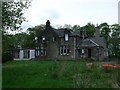
Mount Ellen Golf Club
The derelict clubhouse (Johnston House), the St. Andrews flag still on the mast was abandoned by the golfing membership in 2008.
Image: © Robert Murray
Taken: 13 May 2010
0.08 miles
2
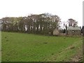
Field, Johnston
Marked on maps as a golf course, this is a field grazed by livestock. The golf course is a bit further back from the road.
Image: © Richard Webb
Taken: 20 Apr 2010
0.10 miles
3
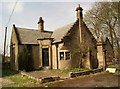
Johnston House Lodge
Built 1902.
Currently unoccupied.
Image: © Texas Radio and The Big Beat
Taken: 24 Apr 2010
0.10 miles
4
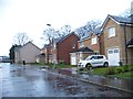
News houses at Mount Ellen Golf Club
Image: © Elliott Simpson
Taken: 23 Nov 2012
0.14 miles
5
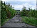
The old road to Marnoch
Long since superseded by a new road over the M73 the fallen tree sort of confirms the No Through Road theme.
Image: © Robert Murray
Taken: 13 May 2010
0.14 miles
6
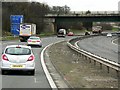
Johnston Road (B804) Bridge over the M73 near Gartcosh
Image: © David Dixon
Taken: 28 Mar 2014
0.19 miles
9
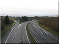
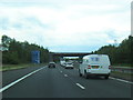
M73 north of Junction 2a
Viewed from the bridge which carries the road from Gartcosh to Glenboig.
Image: © G Laird
Taken: 1 Jan 2014
0.24 miles