IMAGES TAKEN NEAR TO
Langmuir Road, GLASGOW, G69 7TU
Introduction
This page details the photographs taken nearby to Langmuir Road, G69 7TU by members of the Geograph project.
The Geograph project started in 2005 with the aim of publishing, organising and preserving representative images for every square kilometre of Great Britain, Ireland and the Isle of Man.

There are currently over 7.5m images from over14,400 individuals and you can help contribute to the project by visiting https://www.geograph.org.uk
Image Map
Images are licensed for reuse under creativecommons.org/licenses/by-sa/2.0
Notes
- Clicking on the map will re-center to the selected point.
- The higher the marker number, the further away the image location is from the centre of the postcode.
Image Listing (27 Images Found)
Images are licensed for reuse under creativecommons.org/licenses/by-sa/2.0
Image
Details
Distance
1
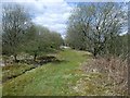
Line of Drumpeller railway
This is the trackbed of the Drumpeller Railway. This line was laid from the Monkland Canal at Cuillhill to the pits in the Bredisholm coalfield along the North Calder. When first laid in 1843 the coal wagons were horse drawn.
The spelling of the line is correct as it was legally known as the Drumpeller and not Drumpellier as might be assumed.
Image: © Robert Murray
Taken: 20 Apr 2010
0.04 miles
2
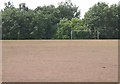
Blaes
A primitive form of all weather football pitch seemingly peculiar to Scotland. The surface is a soft shale, usually red in colour. These leg lacerating pitches are disappearing now. There are two pitches off Langmuir Road.
Image: © Richard Webb
Taken: 25 Jul 2008
0.06 miles
3
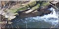
Rock outcrop
An outcrop of the strata on the western bank of the Luggie burn downstream of the viaduct.
Image: © Robert Murray
Taken: 27 Mar 2006
0.06 miles
4
National Cycle Network signpost, Mitchell Street
NCN75 is of no interest to Big Brother. The camera is spying on Mitchell Street beyond.
Image: © Richard Webb
Taken: 25 Jul 2008
0.09 miles
5
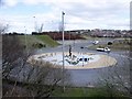
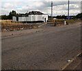
Braehead Roundabout
Junction of A752 Gartcosh - Uddingston road with slip roads to and from the A8 and the adjacent leisure park. North Lanarkshire Council have a policy of making roundabouts interesting an attractive and they haven't failed here.
Image: © Robert Murray
Taken: 20 Apr 2010
0.11 miles
6
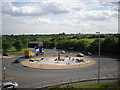
Roundabout, Coatbridge
This roundabout is close to Showcase Leisure Park in Coatbridge
Image: © Stevie Spiers
Taken: 18 Jun 2010
0.11 miles
7
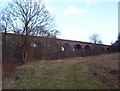
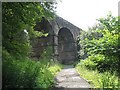
Bargeddie, Luggie Viaduct
Another view of a fine example of sound Victorian engineering.
Image: © Robert Murray
Taken: 27 Mar 2006
0.14 miles
8
Bargeddie, Luggie Viaduct
The first 'train' consisting of an engine, coal tender and wagon carrying Caledonian Railway personnel and contractors crossed this bridge in a trial in 1864 though the whole line never opened until the following year. This bridge is still used by passenger and freight trains many times per day. Victorian engineering par excellance.
Image: © Robert Murray
Taken: 27 Mar 2006
0.14 miles
9
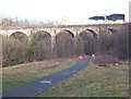
Viaduct over the Luggie Burn
One of the Glasgow - Coatbridge railways passing over the burn and cycle path.
Image: © Richard Webb
Taken: 25 Jul 2008
0.15 miles
10
Langmuir Inn: Bargeddie
Difficult to determine if it's still in business
Image: © Jim Smillie
Taken: 30 Aug 2022
0.16 miles