IMAGES TAKEN NEAR TO
Mainhill Road, GLASGOW, G69 7SS
Introduction
This page details the photographs taken nearby to Mainhill Road, G69 7SS by members of the Geograph project.
The Geograph project started in 2005 with the aim of publishing, organising and preserving representative images for every square kilometre of Great Britain, Ireland and the Isle of Man.

There are currently over 7.5m images from over14,400 individuals and you can help contribute to the project by visiting https://www.geograph.org.uk
Image Map
Images are licensed for reuse under creativecommons.org/licenses/by-sa/2.0
Notes
- Clicking on the map will re-center to the selected point.
- The higher the marker number, the further away the image location is from the centre of the postcode.
Image Listing (34 Images Found)
Images are licensed for reuse under creativecommons.org/licenses/by-sa/2.0
Image
Details
Distance
1
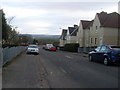
Dykehead Road, Bargeddie
In the distance is Birkenshaw Trading Estate.
Image: © Stephen Sweeney
Taken: 19 Apr 2010
0.04 miles
2
St Kevin's Church
On the edge of Bargeddie
Image: © Jim Smillie
Taken: 30 Aug 2022
0.04 miles
3
Looking to the church on Mainhill Road
From Dykehead Road in Bargeddie.
Image: © Stephen Sweeney
Taken: 19 Apr 2010
0.05 miles
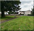
4
![M8 work, Bargeddie [3]](https://s2.geograph.org.uk/geophotos/04/52/86/4528646_04b6944e_120x120.jpg)
M8 work, Bargeddie [3]
The old Bredisholm Road which up till the early 1970s connected Bargeddie with Baillieston and latterly was used as a farming access road is now a builder's yard.
Image: © Robert Murray
Taken: 16 Jun 2015
0.06 miles
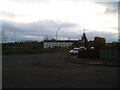
6
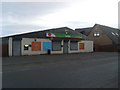
Londis and Post Office
Convenience store in Bargeddie, on Rosebank Terrace.
Image: © Stephen Sweeney
Taken: 19 Apr 2010
0.07 miles
7
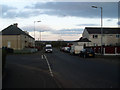
Rosebank Terrace
At the bottom of Monklands View Crescent.
Image: © Stephen Sweeney
Taken: 19 Apr 2010
0.10 miles
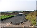
8
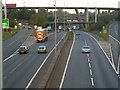
Baillieston Interchange
With the A8 in the foreground and the M8 and M73 in the background.
Image: © Robert Murray
Taken: 19 Oct 2007
0.13 miles
9
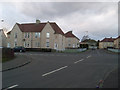
Streets crossing in residential Bargeddie
Dykehead Road at Gartliston Terrace.
Image: © Stephen Sweeney
Taken: 19 Apr 2010
0.15 miles
10
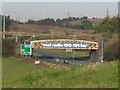
The Cutty Sark Bridge
From the east where they might call it the Real Radio Brig! The spire of Bartonshill church can be seen to the upper right.
Image: © Robert Murray
Taken: 19 Oct 2007
0.15 miles