IMAGES TAKEN NEAR TO
Park Road, GLASGOW, G69 7PL
Introduction
This page details the photographs taken nearby to Park Road, G69 7PL by members of the Geograph project.
The Geograph project started in 2005 with the aim of publishing, organising and preserving representative images for every square kilometre of Great Britain, Ireland and the Isle of Man.

There are currently over 7.5m images from over14,400 individuals and you can help contribute to the project by visiting https://www.geograph.org.uk
Image Map
Images are licensed for reuse under creativecommons.org/licenses/by-sa/2.0
Notes
- Clicking on the map will re-center to the selected point.
- The higher the marker number, the further away the image location is from the centre of the postcode.
Image Listing (16 Images Found)
Images are licensed for reuse under creativecommons.org/licenses/by-sa/2.0
Image
Details
Distance
1
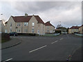
Streets crossing in residential Bargeddie
Dykehead Road at Gartliston Terrace.
Image: © Stephen Sweeney
Taken: 19 Apr 2010
0.09 miles
2
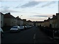
Monkland View Crescent, Bargeddie
Just north of the station.
Image: © Stephen Sweeney
Taken: 19 Apr 2010
0.12 miles
3
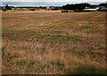
Field of stubble: Drumpark
Large field of recently harvested cereal
Image: © Jim Smillie
Taken: 30 Aug 2022
0.12 miles
4
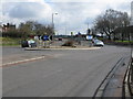
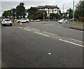
Bargeddie Roundabout
Looking along the A89 in the direction of Coatbridge at the intersection with the A752.
This was one of the last locations I remember seeing tram lines in the Glasgow area long after the disappearance of the trams. The tram lines then occupied the right hand carriageway beyond the roundabout.
Image: © G Laird
Taken: 3 Apr 2010
0.19 miles
5
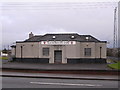
Langmuir Inn
Quality drinking establishment
Image: © Chris Upson
Taken: 3 Dec 2005
0.19 miles
6
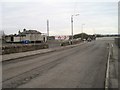
Junction of A89 & A752
Traffic on right coming from Coatbridge.
Large house now operates as a care home.
Image: © Jim Smillie
Taken: 30 Aug 2022
0.19 miles
7
View south on Langmuir Road towards Bargeddie railway station
Image: © Nigel Thompson
Taken: 9 Feb 2017
0.20 miles
8
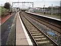
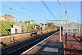
Bargeddie railway station, North Lanarkshire
Opened in 1993 by British Rail on the line from Glasgow Central to Whifflet. View north east towards Kirkwood and Whifflet, following electrification. For a pre-electrification view some three years earlier, see Image
This is also the site of a previous station, one called "Drumpark" was opened here in 1934 by the London Midland & Scottish Railway. It closed in 1964 and was subsequently demolished.
Image: © Nigel Thompson
Taken: 9 Feb 2017
0.20 miles
9
Sunny Skies At Bargeddie Railway Station
A view of Bargeddie Railway station facing the Kirkwood direction, with a lovely clear sky. The overhead electrical equipment is relatively new, being installed in August 2014.
Image: © James Anderson
Taken: 27 Dec 2015
0.20 miles
10
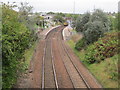
Bargeddie railway station, North Lanarkshire, 2013
Opened in 1993 by British Rail on the line from Glasgow Central to Whifflet. View north east towards Kirkwood and Whifflet prior to electrification. For a post-electrification view some three years later, see Image
This is also the site of a previous station, one called "Drumpark" was opened here in 1934 by the London Midland & Scottish Railway. It closed in 1964 and was subsequently demolished. It had a short goods line curving away sharply to the right.
Image: © Nigel Thompson
Taken: 12 Oct 2013
0.21 miles