IMAGES TAKEN NEAR TO
Gargrave Avenue, GLASGOW, G69 7LW
Introduction
This page details the photographs taken nearby to Gargrave Avenue, G69 7LW by members of the Geograph project.
The Geograph project started in 2005 with the aim of publishing, organising and preserving representative images for every square kilometre of Great Britain, Ireland and the Isle of Man.

There are currently over 7.5m images from over14,400 individuals and you can help contribute to the project by visiting https://www.geograph.org.uk
Image Map
Images are licensed for reuse under creativecommons.org/licenses/by-sa/2.0
Notes
- Clicking on the map will re-center to the selected point.
- The higher the marker number, the further away the image location is from the centre of the postcode.
Image Listing (16 Images Found)
Images are licensed for reuse under creativecommons.org/licenses/by-sa/2.0
Image
Details
Distance
1
Barrachnie, David Place
Built in the late 1960s. Named after David Jaeger, a county councillor who represented the district. The area is commonly called Burntbroom but in fact Burntbroom is to the south and although in a 'legalese' sense it should be called East Mount Vernon as it was part of that old estate I have labelled it Barrachnie as it is just across the road from the old village.
Image: © Robert Murray
Taken: 4 Jun 2005
0.07 miles
2
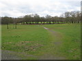
Sherbourne Park
An open area of grassland and trees adjoining Mount Vernon Avenue and Sherburn Gardens.
Image: © G Laird
Taken: 3 Apr 2010
0.14 miles
3
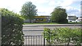
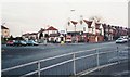
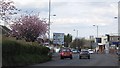
Shop, Glasgow Road
The A89 has a parallel service road serving residential properties.
Image: © Richard Webb
Taken: 23 Apr 2012
0.18 miles
4
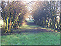
Old Road to Burntbroom
This was the route the road from Barrachnie to Hamilton Road took until the 1960s when Mount Vernon Avenue was re-aligned.
Image: © Robert Murray
Taken: 20 Feb 2004
0.19 miles
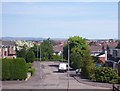
5
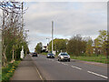
Communication Masts on Mount Vernon Avenue
Sherbourne Park is on the right.
Image: © wrobison
Taken: 20 Apr 2024
0.19 miles
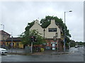
7
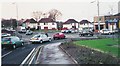
Glasgow Road, Barrachnie
Citywards view near the junction with Mount Vernon Avenue.
Image: © Richard Webb
Taken: 23 Apr 2012
0.22 miles
8
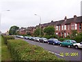
Weirwood Park
Built in the early part of the 19th. century these houses were the first extension to Barrachnie.
Image: © Robert Murray
Taken: 6 Jun 2004
0.22 miles