IMAGES TAKEN NEAR TO
Ellismuir Road, GLASGOW, G69 7JU
Introduction
This page details the photographs taken nearby to Ellismuir Road, G69 7JU by members of the Geograph project.
The Geograph project started in 2005 with the aim of publishing, organising and preserving representative images for every square kilometre of Great Britain, Ireland and the Isle of Man.

There are currently over 7.5m images from over14,400 individuals and you can help contribute to the project by visiting https://www.geograph.org.uk
Image Map
Images are licensed for reuse under creativecommons.org/licenses/by-sa/2.0
Notes
- Clicking on the map will re-center to the selected point.
- The higher the marker number, the further away the image location is from the centre of the postcode.
Image Listing (14 Images Found)
Images are licensed for reuse under creativecommons.org/licenses/by-sa/2.0
Image
Details
Distance
1
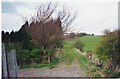
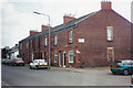
Off Ellismuir Road
A residential street in Crosshill.
Image: © Richard Webb
Taken: 23 Apr 2012
0.09 miles
2
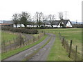
Old Ellismuir road
The original track from Ellismuir Farm over the hill to the parish road between Crosshill and Old Monkland Kirk.
Image: © Robert Murray
Taken: 8 Apr 2003
0.10 miles
3
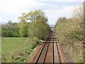
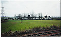
Rutherglen and Coatbridge Railway
View towards Glasgow from a bridge at Ellismuir Farm. The railway was for a long time a freight only route but now carries a passenger service.
Image: © Richard Webb
Taken: 23 Apr 2012
0.14 miles
4
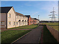
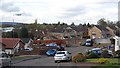
New houses at Ellismuir Park near Baillieston
Part of a large development on the lands of the old Ellismuir farm.
Image: © wrobison
Taken: 6 Mar 2022
0.18 miles
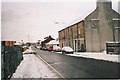
5
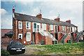
Crosshill, Bredisholm Road
Featuring Wood's Building.
Image: © Robert Murray
Taken: 12 Jun 2003
0.18 miles
6
Crosshill
Wood's Building from the rear.
Image: © Robert Murray
Taken: 12 Jun 2003
0.18 miles
7
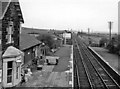
Baillieston Station
View eastwards towards Coatbridge, on Glasgow (Central) - Rutherglen - Coatbridge line. Closed October 1964, when passenger services on route withdrawn, but they were restored 30 years later and a new Baillieston station was built ¼-mile to west in October 1993.
Image: © Ben Brooksbank
Taken: 5 Oct 1961
0.19 miles
8
Crosshill, Bredisholm Road
Mining village of the 19th.century which was separate from Baillieston although consumed by the latter since.
Image: © Robert Murray
Taken: 27 Jan 2003
0.20 miles