IMAGES TAKEN NEAR TO
Burntbroom Gardens, GLASGOW, G69 7HX
Introduction
This page details the photographs taken nearby to Burntbroom Gardens, G69 7HX by members of the Geograph project.
The Geograph project started in 2005 with the aim of publishing, organising and preserving representative images for every square kilometre of Great Britain, Ireland and the Isle of Man.

There are currently over 7.5m images from over14,400 individuals and you can help contribute to the project by visiting https://www.geograph.org.uk
Image Map
Images are licensed for reuse under creativecommons.org/licenses/by-sa/2.0
Notes
- Clicking on the map will re-center to the selected point.
- The higher the marker number, the further away the image location is from the centre of the postcode.
Image Listing (27 Images Found)
Images are licensed for reuse under creativecommons.org/licenses/by-sa/2.0
Image
Details
Distance
1
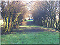
Old Road to Burntbroom
This was the route the road from Barrachnie to Hamilton Road took until the 1960s when Mount Vernon Avenue was re-aligned.
Image: © Robert Murray
Taken: 20 Feb 2004
0.07 miles
2
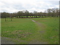
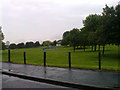
Sherbourne Park
An open area of grassland and trees adjoining Mount Vernon Avenue and Sherburn Gardens.
Image: © G Laird
Taken: 3 Apr 2010
0.13 miles
3
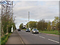
Communication Masts on Mount Vernon Avenue
Sherbourne Park is on the right.
Image: © wrobison
Taken: 20 Apr 2024
0.13 miles
4
Former Glasgow, Bothwell, Hamilton & Coatbridge Railway line
Looking towards the former Mount Vernon North station (1878-1955) and Shettleston. Part of the North British Railway.
Image: © Nigel Thompson
Taken: 9 Feb 2017
0.14 miles
5
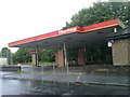
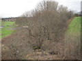
A development opportunity on Mount Vernon Avenue
Image: © Elliott Simpson
Taken: 9 Jun 2014
0.17 miles
7
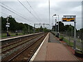
Mount Vernon Railway Station
On the Whifflet Line.
Image: © JThomas
Taken: 13 Sep 2021
0.20 miles
8
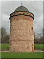
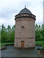
The Daldowie Doocot
This doocot (the pigeonholes can be seen just under the roof) was built on the Daldowie Estate in about 1745, by a wealthy merchant named Bogle, to complement his recently-built country house.
The doocot stands 12.4 metres high, and has a diameter of 6.2 metres. By June of 1999, the building stood in the corner of a sewage works; it had been vandalised, and was in very poor condition: see Image, an earlier picture showing it in that location.
By June of 2000, the building had painstakingly been dismantled, moved one kilometre to its present site, and restored; it is now located on a much more accessible site, close to Mount Vernon railway station (the railway line runs across the background of the photo).
Image: © Lairich Rig
Taken: 1 Apr 2005
0.20 miles
9
Daldowie Doo'cot
Wonderful structure near Hamilton Road. Recently renovated and moved from its original site.
Image: © Stephen Sweeney
Taken: 30 Apr 2009
0.20 miles
10
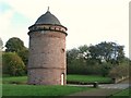
The Daldowie Doocot, Hamilton Road, G71
Image: © Mike Quinn
Taken: 21 Oct 2010
0.21 miles