IMAGES TAKEN NEAR TO
Victory Way, GLASGOW, G69 7HH
Introduction
This page details the photographs taken nearby to Victory Way, G69 7HH by members of the Geograph project.
The Geograph project started in 2005 with the aim of publishing, organising and preserving representative images for every square kilometre of Great Britain, Ireland and the Isle of Man.

There are currently over 7.5m images from over14,400 individuals and you can help contribute to the project by visiting https://www.geograph.org.uk
Image Map
Images are licensed for reuse under creativecommons.org/licenses/by-sa/2.0
Notes
- Clicking on the map will re-center to the selected point.
- The higher the marker number, the further away the image location is from the centre of the postcode.
Image Listing (48 Images Found)
Images are licensed for reuse under creativecommons.org/licenses/by-sa/2.0
Image
Details
Distance
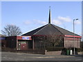
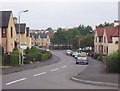
1

Baillieston, Victory Way
Located off Nelson Street, the councillor who suggested the name probably linked the former and the latter.
The development was built by John M. Norman Ltd. of Bellshill in 1968/69 for Lanarkshire county council. Prior to this the site was occupied by 'Pre-Fabs' built soon after WW2 to alleviate a chronic housing shortage.
Image: © Robert Murray
Taken: 4 May 2005
0.03 miles
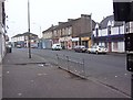
2
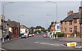
Baillieston, Main Street
Looking west on a quiet Sunday morning. The Keep Left sign has had an accident.
Image: © Robert Murray
Taken: 22 Jun 2003
0.09 miles
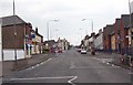
3
Baillieston, South Scott Street
Resplendent in the sun.
Image: © Robert Murray
Taken: 16 Jun 2002
0.09 miles
4
South Scott Street, Baillieston
This first part of this street was laid down in 1936; it dissects the area known as The Bauks. The street was named after land owner George Scott Nelson-Scott of Daldowie.
Image: © Robert Murray
Taken: 5 Jul 2008
0.09 miles
5
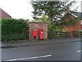
Post box on Muirhead Road
In Baillieston.
Image: © Stephen Sweeney
Taken: 30 Apr 2009
0.09 miles
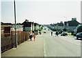
6
Baillieston, Main Street
Deserted scene at 8am on a Sunday morning. The pub on the right which is known to Bailliestonians as the Auld Hoose has changed its trading name again.
Image: © Robert Murray
Taken: 4 Jun 2007
0.09 miles
7
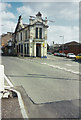
Baillieston, Main Street
Prominent in the photo is the building sitting at the junction of Main Street and Church Street. This was built in 1888 and was called the Old Toll Hotel.
Image: © Robert Murray
Taken: 12 Jun 2003
0.10 miles
8
Baillieston, Main Street
On a quiet Sunday morning.
Image: © Robert Murray
Taken: 22 Jun 2003
0.10 miles
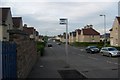
9
Baillieston, Nelson Street
The eastern end at Muirhead Road.
Image: © Robert Murray
Taken: 29 Sep 2008
0.11 miles