IMAGES TAKEN NEAR TO
Muirhead Road, GLASGOW, G69 7HB
Introduction
This page details the photographs taken nearby to Muirhead Road, G69 7HB by members of the Geograph project.
The Geograph project started in 2005 with the aim of publishing, organising and preserving representative images for every square kilometre of Great Britain, Ireland and the Isle of Man.

There are currently over 7.5m images from over14,400 individuals and you can help contribute to the project by visiting https://www.geograph.org.uk
Image Map
Images are licensed for reuse under creativecommons.org/licenses/by-sa/2.0
Notes
- Clicking on the map will re-center to the selected point.
- The higher the marker number, the further away the image location is from the centre of the postcode.
Image Listing (48 Images Found)
Images are licensed for reuse under creativecommons.org/licenses/by-sa/2.0
Image
Details
Distance
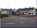
1
Baillieston, Muirhead Road
The two nearest villas occupy the site of the original row of weaver's cottages built in 1780 that was named 'Muirhead'.
Image: © Robert Murray
Taken: 12 Jun 2003
0.05 miles
2
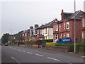
Baillieston, Muirhead Road
Fine Victorian villas built in the latter half of the nineteenth century. This street was a parish road.
Image: © Robert Murray
Taken: 10 Jun 2003
0.05 miles
3
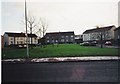
Baillieston, Nelson Street
The eastern end at Muirhead Road.
Image: © Robert Murray
Taken: 29 Sep 2008
0.07 miles
4
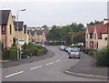
Baillieston, Calder Place
Post war housing, originally named 'The Bauks' - after the historic name of the area the name was changed to the present in 1951 by Lanarkshire county council after complaints by some residents who objected to the name. The present appellation is a bland reference to a nearby river.
Image: © Robert Murray
Taken: 12 Feb 2002
0.08 miles
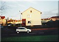
5
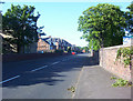
Baillieston, Loancroft Place
Post-War local authourity housing [of high quality] built in 1958.
Image: © Robert Murray
Taken: 8 May 2004
0.09 miles
7
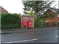
Post box on Muirhead Road
In Baillieston.
Image: © Stephen Sweeney
Taken: 30 Apr 2009
0.09 miles
8
Baillieston, Calder Place from Muirside Street.
Originally named the 'Bauks'- there are people with that address on their birth certificates - the name was changed in 1951 after complaints by residents - and so they got the really upmarket fancy name of Calder Place.
Shame on them and shame on Lanarkshire county council for bowing to eedjits and sinking history.
Image: © Robert Murray
Taken: 23 Mar 2003
0.10 miles
9
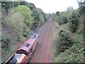
Baillieston 1st railway station (site), Glasgow
Around 500m ahead of the train is the site of the first Baillieston station. Opened in 1866 by the Rutherglen and Coatbridge Railway, later part of the Caledonian Railway empire, this station closed in 1964. View north east towards Bargeddie and Whifflet. The site is now lost under a new housing estate and..... quite a lot of greenery.
When the line was reopened to passengers in 1993 as part of the Glasgow to Whifflet line, the replacement Baillieston station was located just behind the camera position.
Image: © Nigel Thompson
Taken: 12 Oct 2013
0.12 miles
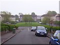
10
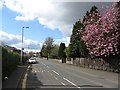
Muirhead Road
Blossom in Baillieston.
Image: © Richard Webb
Taken: 23 Apr 2012
0.12 miles