IMAGES TAKEN NEAR TO
Dow Place, GLASGOW, G69 7FP
Introduction
This page details the photographs taken nearby to Dow Place, G69 7FP by members of the Geograph project.
The Geograph project started in 2005 with the aim of publishing, organising and preserving representative images for every square kilometre of Great Britain, Ireland and the Isle of Man.

There are currently over 7.5m images from over14,400 individuals and you can help contribute to the project by visiting https://www.geograph.org.uk
Image Map
Images are licensed for reuse under creativecommons.org/licenses/by-sa/2.0
Notes
- Clicking on the map will re-center to the selected point.
- The higher the marker number, the further away the image location is from the centre of the postcode.
Image Listing (7 Images Found)
Images are licensed for reuse under creativecommons.org/licenses/by-sa/2.0
Image
Details
Distance
1
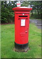
Elizabethan postbox on Oakridge Road, Coatbridge
Postbox No. G69 1531.
See Image] for context.
Image: © JThomas
Taken: 29 Jun 2017
0.14 miles
2
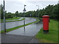
Oakridge Road, Coatbridge
Looking north showing position of Postbox No. G69 1531.
Image: © JThomas
Taken: 29 Jun 2017
0.16 miles
3
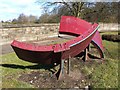
Industrial artwork beside Glasgow Road
Here, on the northern side of Glasgow Road, what appear to be sections of a tunnel or large pipeline have been installed in several groups on the grass verge. See Image, an earlier photograph, which provides more context.
The course of Drumpellier Golf Club is located behind the stone wall in the background.
I was unable to find out anything more about these objects. However, I am grateful to a fellow contributor – http://www.geograph.org.uk/profile/10850 – who tells me that they were installed here in the 1970s, on the former route of the road, and that "the existing dual carriageway follows the old Baillieston – Langloan tramway (private line), and the current route of the (A89) road was straightened by cutting into the line of the tramway at this bend" (thanks again for the information).
Image: © Lairich Rig
Taken: 11 Mar 2005
0.19 miles
4
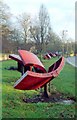
Industrial artwork beside Glasgow Road
For a closer look at the nearest group, and for further information, see Image
Image: © Lairich Rig
Taken: 10 Dec 2004
0.20 miles
5
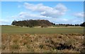
Field near Bargeddie
The picture was taken from the pavement on the northern side of Glasgow Road (as the road is called from about this point eastward), near a bus stop (I paused at the bus stop to consult my street atlas, to decide where to head next).
The area of woodland in the background is depicted on the map; beyond it, over the brow of the hill, is the Drumpellier estate.
Image: © Lairich Rig
Taken: 11 Mar 2005
0.21 miles
6

Path beside the Luggie Burn
National Cycle Route 75 heading southwards from Coatbridge beside the Luggie Water.
Image: © Richard Webb
Taken: 25 Jul 2008
0.21 miles
7

Path beside the Luggie Burn
National Cycle Route 75 heading southwards from Coatbridge beside the Luggie Water.
Image: © Richard Webb
Taken: 25 Jul 2008
0.22 miles