IMAGES TAKEN NEAR TO
Oakhill Avenue, GLASGOW, G69 7ES
Introduction
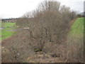
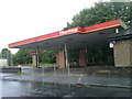
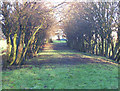
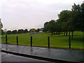
This page details the photographs taken nearby to Oakhill Avenue, G69 7ES by members of the Geograph project.
The Geograph project started in 2005 with the aim of publishing, organising and preserving representative images for every square kilometre of Great Britain, Ireland and the Isle of Man.

There are currently over 7.5m images from over14,400 individuals and you can help contribute to the project by visiting https://www.geograph.org.uk
Image Map (Loading...)


Getting Data...Please wait
Leaflet Map data © OpenStreetMap
Images are licensed for reuse under creativecommons.org/licenses/by-sa/2.0
Notes
- Clicking on the map will re-center to the selected point.
- The higher the marker number, the further away the image location is from the centre of the postcode.
Image Listing (29 Images Found)
Images are licensed for reuse under creativecommons.org/licenses/by-sa/2.0
Image
Details
Distance
1
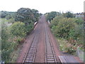
Former Glasgow, Bothwell, Hamilton & Coatbridge Railway line
Looking towards the former Mount Vernon North station (1878-1955) and Shettleston. Part of the North British Railway.
Image: © Nigel Thompson
Taken: 9 Feb 2017
0.10 miles
2
A development opportunity on Mount Vernon Avenue
Image: © Elliott Simpson
Taken: 9 Jun 2014
0.11 miles
3
Old Road to Burntbroom
This was the route the road from Barrachnie to Hamilton Road took until the 1960s when Mount Vernon Avenue was re-aligned.
Image: © Robert Murray
Taken: 20 Feb 2004
0.12 miles
5
Mount Vernon Railway Station
On the Whifflet Line.
Image: © JThomas
Taken: 13 Sep 2021
0.15 miles
6
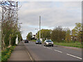
Communication Masts on Mount Vernon Avenue
Sherbourne Park is on the right.
Image: © wrobison
Taken: 20 Apr 2024
0.16 miles
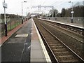
7
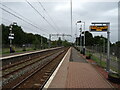
Mount Vernon railway station, Glasgow, 2013
Opened in 1866 by the Rutherglen and Coatbridge Railway, later part of the Caledonian Railway empire, this station closed in 1943. It was rebuilt and reopened in 1993 as part of the Glasgow to Whifflet line.
View south west towards Carmyle and Glasgow, prior to electrification. For the same view some three years later, see Image
Image: © Nigel Thompson
Taken: 12 Oct 2013
0.17 miles
8
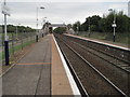
Mount Vernon railway station, looking ENE
View from footbridge at Mount Vernon railway station, looking roughly ENE towards Whifflet.
Image: © Andrew Reid
Taken: 23 Sep 2011
0.17 miles
9
Mount Vernon railway station, looking WSW
View from footbridge at Mount Vernon railway station, looking roughly WSW towards Glasgow Central.
Image: © Andrew Reid
Taken: 23 Sep 2011
0.17 miles
10
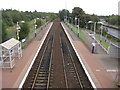
Mount Vernon railway station, Glasgow
Opened in 1866 by the Rutherglen and Coatbridge Railway, later part of the Caledonian Railway, this station closed in 1943. It was rebuilt and reopened in 1993 as part of the Glasgow to Whifflet line.
View south west towards Carmyle and Glasgow following electrification. For the same view some three years earlier, see Image
Image: © Nigel Thompson
Taken: 9 Feb 2017
0.17 miles