IMAGES TAKEN NEAR TO
Caledonia Road, GLASGOW, G69 7DQ
Introduction
This page details the photographs taken nearby to Caledonia Road, G69 7DQ by members of the Geograph project.
The Geograph project started in 2005 with the aim of publishing, organising and preserving representative images for every square kilometre of Great Britain, Ireland and the Isle of Man.

There are currently over 7.5m images from over14,400 individuals and you can help contribute to the project by visiting https://www.geograph.org.uk
Image Map
Images are licensed for reuse under creativecommons.org/licenses/by-sa/2.0
Notes
- Clicking on the map will re-center to the selected point.
- The higher the marker number, the further away the image location is from the centre of the postcode.
Image Listing (58 Images Found)
Images are licensed for reuse under creativecommons.org/licenses/by-sa/2.0
Image
Details
Distance
1
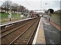
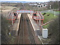
Baillieston railway station, Glasgow
Opened in 1993 by British Rail on the reopened line from Glasgow Central to Whifflet.
View north east after electrification, towards the original station site, around 500m further west, and Whifflet. For a pre-electrification view in the opposite direction some three years earlier, see Image
Image: © Nigel Thompson
Taken: 9 Feb 2017
0.04 miles
3
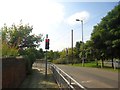
Baillieston, Muirhead Road
Traffic lights limiting traffic to one way at a time over the viaduct built in 1863.
Image: © Robert Murray
Taken: 25 Aug 2013
0.05 miles
4
Weak bridge over railway
In Baillieston.
Image: © Stephen Sweeney
Taken: 30 Apr 2009
0.05 miles
5
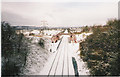
Ballieston Station from Boghall Road
Image: © Stephen Sweeney
Taken: 30 Apr 2009
0.05 miles
6

Baillieston railway station, Glasgow
Opened in 1993 by British Rail on the reopened line from Glasgow Central to Whifflet. The previous station had been around 500m further east.
View south west towards Mount Vernon and Glasgow, just prior to electrification of the line. For a post-electrification view in the opposite direction some three years later, see Image
Image: © Nigel Thompson
Taken: 12 Oct 2013
0.05 miles
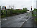
7
![Baillieston, Muirhead Road [2]](https://s0.geograph.org.uk/geophotos/03/62/88/3628864_1bf922f0_120x120.jpg)
Baillieston, Muirhead Road [2]
The viaduct built by the Caledonian Railway in 1863 to carry horse drawn traffic. See also Image
Image: © Robert Murray
Taken: 25 Aug 2013
0.06 miles
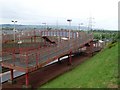
8
Baillieston, railway line
The new station (in reality a halt) opened in 1993. The current label for this line is the Whifflet Line but it was originally the Rutherglen to Coatbridge branch line of the Caledonian Railway. A mineral line to service the coalfields either side of the North Calder it opened for freight in 1865.
Image: © Robert Murray
Taken: 27 Jan 2003
0.06 miles
9
Baillieston Railway Station
The station between Mount Vernon and Bargeddie on the Glasgow to Whifflet railway line.
Image: © G Laird
Taken: 28 Mar 2010
0.06 miles
10
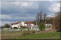
Baillieston Station
A new railway station which was built when the Rutherglen and Coatbridge line was reopened to passenger traffic. There is a lot of new housing development in the area.
Image: © Richard Webb
Taken: 23 Apr 2012
0.06 miles