IMAGES TAKEN NEAR TO
Neidpath, GLASGOW, G69 7BU
Introduction
This page details the photographs taken nearby to Neidpath, G69 7BU by members of the Geograph project.
The Geograph project started in 2005 with the aim of publishing, organising and preserving representative images for every square kilometre of Great Britain, Ireland and the Isle of Man.

There are currently over 7.5m images from over14,400 individuals and you can help contribute to the project by visiting https://www.geograph.org.uk
Image Map
Images are licensed for reuse under creativecommons.org/licenses/by-sa/2.0
Notes
- Clicking on the map will re-center to the selected point.
- The higher the marker number, the further away the image location is from the centre of the postcode.
Image Listing (16 Images Found)
Images are licensed for reuse under creativecommons.org/licenses/by-sa/2.0
Image
Details
Distance
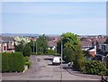
1
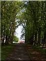
The Avenue of the old site of Baillieston House
Looking north. This arch of trees were planted in the early part of the 19th.century by a Major James Maxwell, proprietor of Baillieston estate.
Image: © Robert Murray
Taken: 25 Jul 2005
0.09 miles
2
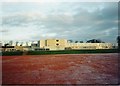
Bannerman High School, Baillieston
Named in 1973 after the retiring county architect.
Image: © Robert Murray
Taken: 12 Feb 2002
0.12 miles
3
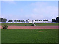
Bannerman High School, Baillieston
Opened in 1973 on the grounds of the old Baillieston Estate this magnificent new edifice, a comprehensive school no less replaced among others Baillieston Secondary School.
Image: © Robert Murray
Taken: 16 Jun 2004
0.12 miles
4
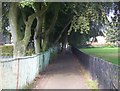
Suburban Lane
The trees are a relic of the marches of Baillieston Estate and the path lies over a culverted burn.
Image: © Robert Murray
Taken: 12 Jun 2004
0.14 miles
5
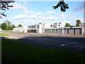
Bannerman High School, Baillieston
The front view. This was probably the last school ever built by Lanarkshire county council before local government re-organisation in 1975.
Image: © Robert Murray
Taken: 16 Jun 2004
0.15 miles
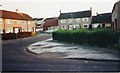
6
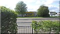
Shop, Glasgow Road
The A89 has a parallel service road serving residential properties.
Image: © Richard Webb
Taken: 23 Apr 2012
0.16 miles
7
Baillieston, Beauly Road
Looking down the brae.
Image: © Robert Murray
Taken: 16 Jun 2004
0.16 miles
8
Baillieston, Huntingtower Road
Broom housing estate built 1964 onwards by Lanarkshire county council.
Image: © Robert Murray
Taken: 16 Jun 2004
0.18 miles
9
Barrachnie, David Place
Built in the late 1960s. Named after David Jaeger, a county councillor who represented the district. The area is commonly called Burntbroom but in fact Burntbroom is to the south and although in a 'legalese' sense it should be called East Mount Vernon as it was part of that old estate I have labelled it Barrachnie as it is just across the road from the old village.
Image: © Robert Murray
Taken: 4 Jun 2005
0.19 miles
10
Baillieston, Fir Place
Like the other two streets built in the late 1950s leading off Old Wood Road this little cul-de-sac was given a tree name.
Image: © Robert Murray
Taken: 12 Feb 2002
0.19 miles