IMAGES TAKEN NEAR TO
Cuilhill Road, GLASGOW, G69 6UF
Introduction
This page details the photographs taken nearby to Cuilhill Road, G69 6UF by members of the Geograph project.
The Geograph project started in 2005 with the aim of publishing, organising and preserving representative images for every square kilometre of Great Britain, Ireland and the Isle of Man.

There are currently over 7.5m images from over14,400 individuals and you can help contribute to the project by visiting https://www.geograph.org.uk
Image Map
Images are licensed for reuse under creativecommons.org/licenses/by-sa/2.0
Notes
- Clicking on the map will re-center to the selected point.
- The higher the marker number, the further away the image location is from the centre of the postcode.
Image Listing (25 Images Found)
Images are licensed for reuse under creativecommons.org/licenses/by-sa/2.0
Image
Details
Distance
1
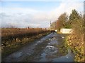
Heatheryknowe Road
The eastern half of Heatheryknowe Road, which ceased to be a through road around 1970 when it was chopped in two by the construction of the M73. Traffic wishing to access the west side will use Commonhead Road to the north.
Image: © Richard Webb
Taken: 18 Jan 2009
0.04 miles
4
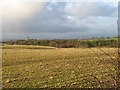
Fields beside the M73
Looking across from a road severed by the motorway towards Bargeddie church.
Image: © Richard Webb
Taken: 18 Jan 2009
0.08 miles
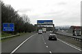
5
Looking south down M73 from Commonhead Road
Image: © Chris Upson
Taken: 26 Feb 2006
0.08 miles
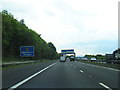
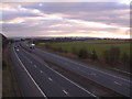
6

M73 west of Coatbridge
Looking south with the overhead gantry signs indicating the junction with the M8 just ahead.
Image: © G Laird
Taken: 10 Mar 2012
0.10 miles
7
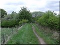
Track to Drumpellier Country Park
And the woods south of Lochend Loch.
Image: © Robert Murray
Taken: 13 May 2010
0.12 miles
8
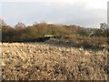
Drumpelier Country Park
What looks like a former field between a disused railway, and beyond the railway some rough woodland on an old colliery site, and the A752. A large area of old industrial land and woodland is now managed as a country park.
Image: © Richard Webb
Taken: 18 Jan 2009
0.13 miles
9

Crop field off Cuilhill Road
Looking east towards a disused railway.
Image: © JThomas
Taken: 29 Jun 2017
0.13 miles
10
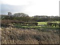
Pasture by Cuilhill Road
Across a track leading into Drumpelier Country Park into some well drained grazing land.
Image: © Richard Webb
Taken: 18 Jan 2009
0.14 miles