IMAGES TAKEN NEAR TO
Cuilhill Road, GLASGOW, G69 6UE
Introduction
This page details the photographs taken nearby to Cuilhill Road, G69 6UE by members of the Geograph project.
The Geograph project started in 2005 with the aim of publishing, organising and preserving representative images for every square kilometre of Great Britain, Ireland and the Isle of Man.

There are currently over 7.5m images from over14,400 individuals and you can help contribute to the project by visiting https://www.geograph.org.uk
Image Map
Images are licensed for reuse under creativecommons.org/licenses/by-sa/2.0
Notes
- Clicking on the map will re-center to the selected point.
- The higher the marker number, the further away the image location is from the centre of the postcode.
Image Listing (31 Images Found)
Images are licensed for reuse under creativecommons.org/licenses/by-sa/2.0
Image
Details
Distance
1
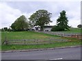
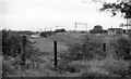
Cuillhill
Formerly a community of two miner's rows on the banks of the Monkland Canal which had its own flute band.
Image: © Robert Murray
Taken: 13 May 2010
0.03 miles
3
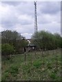
Railway store and radio mast
The little building might have been built as a detonator store in the last days of steam.
Image: © Robert Murray
Taken: 13 May 2010
0.10 miles
4

Railway coach being burnt at Scrapyard near Bargeddie
In 1961 this was the site by the ex-North British line between Glasgow and Coatbridge, where much rolling-stock was being broken up for scrap. The coach appears to be an ex-NB non-corridor vehicle.
Image: © Ben Brooksbank
Taken: 5 Oct 1961
0.11 miles
5
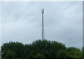
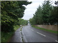
Communications mast
View from Cuilhill Road.
Image: © JThomas
Taken: 29 Jun 2017
0.11 miles
6
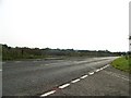
Site of Bargeddie Station
This is the then recently electrified Helensburgh - Glasgow (Queen Street Low Level) - Coatbridge - Airdrie line, with seemingly no trace of Bargeddie station, as it was closed to passengers on 24/9/27 (but not for Goods until 6/7/64). On 4/10/93 a new Bargeddie station was opened on the Glasgow (Central) - Rutherglen - Whifflet line, as seen on the modern map at NS6963. Confusing?
Image: © Ben Brooksbank
Taken: 5 Oct 1961
0.12 miles
7
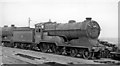
'Lucy Ashton', an LNE 4-4-0, awaits her fate at the Bargeddie Scrapyard
Together with a sister engine behind her, No. 62680 'Lucy Ashton' (a D11/2 'Improved Director' 4-4-0), which had been since 1924 on LNER (ex-North British) passenger trains in Central Scotland, was recently condemned at Eastfield (Glasgow) Shed and is 'awaiting the torch', next to the LMS 4-4-0 depicted in Image
Image: © Ben Brooksbank
Taken: 5 Oct 1961
0.13 miles

10
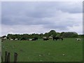
Grazing cows at Cuillhill
Everyone a bull.
Image: © Robert Murray
Taken: 13 May 2010
0.14 miles