IMAGES TAKEN NEAR TO
Rogerfield Road, GLASGOW, G69 6TT
Introduction
This page details the photographs taken nearby to Rogerfield Road, G69 6TT by members of the Geograph project.
The Geograph project started in 2005 with the aim of publishing, organising and preserving representative images for every square kilometre of Great Britain, Ireland and the Isle of Man.

There are currently over 7.5m images from over14,400 individuals and you can help contribute to the project by visiting https://www.geograph.org.uk
Image Map
Images are licensed for reuse under creativecommons.org/licenses/by-sa/2.0
Notes
- Clicking on the map will re-center to the selected point.
- The higher the marker number, the further away the image location is from the centre of the postcode.
Image Listing (9 Images Found)
Images are licensed for reuse under creativecommons.org/licenses/by-sa/2.0
Image
Details
Distance
1
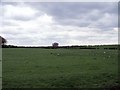
Commonhead Enclosure
Surrounded on two sides by roads and on the other by a burn this field was one of the first in Old Monkland parish to be 'enclosed' in the 'Agricultural Revolution' of the late 18th. and early 19th. centuries.
Image: © Robert Murray
Taken: 13 May 2010
0.16 miles
2

Easterhouse, Monkland Canal
The filled in route of the Monkland Canal strangled by vegetation looking east towards Netherhouse Bridge from the old village of West Merryston or the 'Hole' as it was usually known as.
Image: © Robert Murray
Taken: 27 Mar 2006
0.16 miles
3
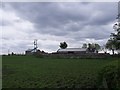
Netherhouse Farm
The oldest part of this farm is situated to the left.
Image: © Robert Murray
Taken: 13 May 2010
0.18 miles
4

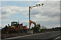
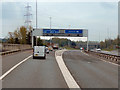
Glasgow City : The M8 Motorway - Roadworks
People working on the side of the motorway.
Image: © Lewis Clarke
Taken: 25 Apr 2016
0.21 miles
5
Glasgow City : The M8 Motorway - Roadworks
Roadworks taking place on the side of the motorway.
Image: © Lewis Clarke
Taken: 25 Apr 2016
0.22 miles
6
Railway near Easterhouse
The line between Easterhouse and Blairhill stations, viewed from the M8 motorway.
Image: © Thomas Nugent
Taken: 23 Feb 2020
0.23 miles
8
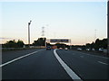
M8, Swinton (Junction 8)
The exit slip road from the M8 (junction 8) for the M73/M74 motorways.
Note the typical “Glasgow-type” sign gantry advising of the approaching junction 15 as the slip road from junction 16 joins from the left. With the following distinctive elements:
• Near and offside support legs (basically 2 rectangular hollow sections with base plates to allow connections to the foundations)
• A Main Frame (made up of rectangular hollow sections) - Over clad on the front and rear.
• A Sub Frame (made up of smaller hollow sections and welded to main frame).
• A Sign Face - acrylic sheets hung from the front of the sub frame over its full height.
• Internal Electrics - sign lighting provided through the use of several dozen fluorescent battens.
Gantries of this type were erected as part of the construction of the Kingston Bridge and its approach roads in 1970 and they are now a familiar sight on the network around Glasgow.
More information on “Glasgow Style Gantries” at http://www.glasgows-motorways.co.uk/glasgow-gantries/4578281645 (Glasgow’s Motorways)
Image: © David Dixon
Taken: 20 Apr 2012
0.24 miles
9
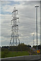
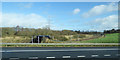
Glasgow City : Grassy Field & Pylon
A pylon seen alongside the M8 Motorway.
Image: © Lewis Clarke
Taken: 25 Apr 2016
0.24 miles