IMAGES TAKEN NEAR TO
Micklehouse Place, GLASGOW, G69 6TH
Introduction
This page details the photographs taken nearby to Micklehouse Place, G69 6TH by members of the Geograph project.
The Geograph project started in 2005 with the aim of publishing, organising and preserving representative images for every square kilometre of Great Britain, Ireland and the Isle of Man.

There are currently over 7.5m images from over14,400 individuals and you can help contribute to the project by visiting https://www.geograph.org.uk
Image Map
Images are licensed for reuse under creativecommons.org/licenses/by-sa/2.0
Notes
- Clicking on the map will re-center to the selected point.
- The higher the marker number, the further away the image location is from the centre of the postcode.
Image Listing (5 Images Found)
Images are licensed for reuse under creativecommons.org/licenses/by-sa/2.0
Image
Details
Distance
1
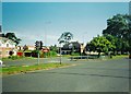
Garrowhill, Edinburgh Road
The prominent building is the Springcroft Tavern.
Image: © Robert Murray
Taken: 16 Jun 2002
0.14 miles
2
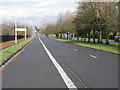
Edinburgh Road, Glasgow (A8)
Prior to the M8 opening, this was indeed a very busy road into Glasgow. The bus lane rarely appears to be necessary!
Image: © G Laird
Taken: 3 Apr 2010
0.15 miles
3
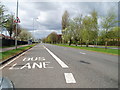
Bus Lane Edinburgh Road
Looking in the direction of Glasgow city centre.
Image: © Gordon Dowie
Taken: 29 Apr 2010
0.16 miles
4
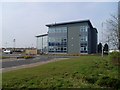
Glasgow Business Park
Situated at Junction 9 of the M8, between Easterhouse and Baillieston.
Image: © Stephen Sweeney
Taken: 20 Apr 2009
0.17 miles
5
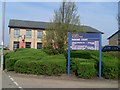
Parkway Court
Business premises in Glasgow Business Park.
Image: © Stephen Sweeney
Taken: 20 Apr 2009
0.24 miles