IMAGES TAKEN NEAR TO
Thornbridge Road, GLASGOW, G69 6RA
Introduction
This page details the photographs taken nearby to Thornbridge Road, G69 6RA by members of the Geograph project.
The Geograph project started in 2005 with the aim of publishing, organising and preserving representative images for every square kilometre of Great Britain, Ireland and the Isle of Man.

There are currently over 7.5m images from over14,400 individuals and you can help contribute to the project by visiting https://www.geograph.org.uk
Image Map
Images are licensed for reuse under creativecommons.org/licenses/by-sa/2.0
Notes
- Clicking on the map will re-center to the selected point.
- The higher the marker number, the further away the image location is from the centre of the postcode.
Image Listing (7 Images Found)
Images are licensed for reuse under creativecommons.org/licenses/by-sa/2.0
Image
Details
Distance
1
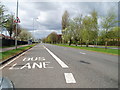
Bus Lane Edinburgh Road
Looking in the direction of Glasgow city centre.
Image: © Gordon Dowie
Taken: 29 Apr 2010
0.07 miles
2
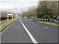
Edinburgh Road, Glasgow (A8)
Prior to the M8 opening, this was indeed a very busy road into Glasgow. The bus lane rarely appears to be necessary!
Image: © G Laird
Taken: 3 Apr 2010
0.07 miles
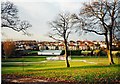
3
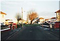
Garrowhill, Thornbridge Road
The original shops of the Garrowhill garden suburb can be seen to the left and right on the north side of the roundabout.
Image: © Robert Murray
Taken: 12 Feb 2002
0.09 miles
4
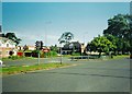
Garrowhill, Edinburgh Road
The prominent building is the Springcroft Tavern.
Image: © Robert Murray
Taken: 16 Jun 2002
0.14 miles
5
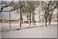
Garrowhill, the park
Looking across the Drive and through the trees towards the school.
Image: © Robert Murray
Taken: 27 Jan 2003
0.17 miles
6
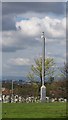
Garrowhill Park
A CCTV camera on a hill top location in the middle of the park.
Image: © Richard Webb
Taken: 23 Apr 2012
0.20 miles
7
Garrowhill, the park
Looking towards the bowling green from the ridge.
Image: © Robert Murray
Taken: 12 Feb 2002
0.25 miles