IMAGES TAKEN NEAR TO
Hathersage Gardens, GLASGOW, G69 6QQ
Introduction
This page details the photographs taken nearby to Hathersage Gardens, G69 6QQ by members of the Geograph project.
The Geograph project started in 2005 with the aim of publishing, organising and preserving representative images for every square kilometre of Great Britain, Ireland and the Isle of Man.

There are currently over 7.5m images from over14,400 individuals and you can help contribute to the project by visiting https://www.geograph.org.uk
Image Map
Images are licensed for reuse under creativecommons.org/licenses/by-sa/2.0
Notes
- Clicking on the map will re-center to the selected point.
- The higher the marker number, the further away the image location is from the centre of the postcode.
Image Listing (21 Images Found)
Images are licensed for reuse under creativecommons.org/licenses/by-sa/2.0
Image
Details
Distance
1
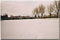
Baillieston, Springhill Park
A public football park known locally as 'Maxies'. It was originally laid out by Baillieston Juniors FC in 1933 and was their home park until they moved to Station Park in 1953.
Image: © Robert Murray
Taken: 27 Jan 2003
0.09 miles
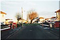
2
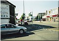
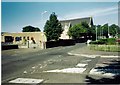
Baillieston, Main Street
At the junction of South Scott Street.
Image: © Robert Murray
Taken: 16 Jun 2002
0.13 miles
3
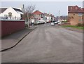
Baillieston, Longlee
One of the oldest names in Baillieston.
Image: © Robert Murray
Taken: 3 Apr 2005
0.14 miles
4
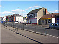
Baillieston, Main Street
This area is considered as the 'West End'. The police station is in the picture.
Image: © Robert Murray
Taken: 18 Jul 2004
0.15 miles
5
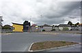
Garrowhill, Thornbridge Road
The original shops of the Garrowhill garden suburb can be seen to the left and right on the north side of the roundabout.
Image: © Robert Murray
Taken: 12 Feb 2002
0.15 miles
6
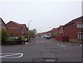
Baillieston, Buchanan Gardens
Built in the 1990s on the site of Baillieston Secondary School.
Image: © Robert Murray
Taken: 4 Jun 2007
0.15 miles
7
Main Street, Baillieston
First run the buses in Glasgow.
Image: © Richard Webb
Taken: 23 Apr 2012
0.15 miles
8
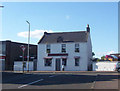
Baillieston, Main Street
At the junction with South Scott Street. The building in focus is a shop known to all as "Irene's", in previous lives it has been the local branch of the Airdrie Savings Bank http://www.airdriesavingsbank.net/ and prior to that the office of the Airdrie & Coatbridge Water Board.
Image: © Robert Murray
Taken: 18 Jul 2004
0.16 miles
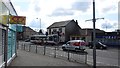
9
Baillieston, St. Bridgets Church
With social club hall in view.
Image: © Robert Murray
Taken: 16 Jun 2002
0.16 miles
10
Baillieston Health Centre
At Muirside Road. This facility replaced about five independent GP practises dotted around the village in the early 1980s.
Image: © Robert Murray
Taken: 18 Jul 2004
0.17 miles