IMAGES TAKEN NEAR TO
Barrachnie Road, GLASGOW, G69 6HB
Introduction
This page details the photographs taken nearby to Barrachnie Road, G69 6HB by members of the Geograph project.
The Geograph project started in 2005 with the aim of publishing, organising and preserving representative images for every square kilometre of Great Britain, Ireland and the Isle of Man.

There are currently over 7.5m images from over14,400 individuals and you can help contribute to the project by visiting https://www.geograph.org.uk
Image Map
Images are licensed for reuse under creativecommons.org/licenses/by-sa/2.0
Notes
- Clicking on the map will re-center to the selected point.
- The higher the marker number, the further away the image location is from the centre of the postcode.
Image Listing (22 Images Found)
Images are licensed for reuse under creativecommons.org/licenses/by-sa/2.0
Image
Details
Distance
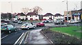
1
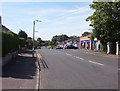
Barrachnie
The site of the old village and still retaining the ancient name.
Image: © Robert Murray
Taken: 10 Jun 2005
0.01 miles
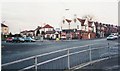
2
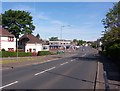
View of Barrachnie
From the south at Mount Vernon Avenue.
Image: © Robert Murray
Taken: 10 Jun 2005
0.05 miles
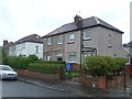
8
Glasgow Road, Barrachnie
Citywards view near the junction with Mount Vernon Avenue.
Image: © Richard Webb
Taken: 23 Apr 2012
0.07 miles
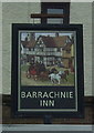
9
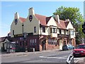
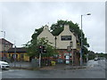
The Barrachnie Inn
Built around 1938.
Image: © Robert Murray
Taken: 10 Jun 2005
0.07 miles
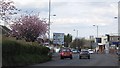
10
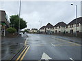
Baillieston Road (A89)
Looking south east.
Image: © JThomas
Taken: 29 Jun 2017
0.08 miles