IMAGES TAKEN NEAR TO
Robertson Terrace, GLASGOW, G69 6DJ
Introduction
This page details the photographs taken nearby to Robertson Terrace, G69 6DJ by members of the Geograph project.
The Geograph project started in 2005 with the aim of publishing, organising and preserving representative images for every square kilometre of Great Britain, Ireland and the Isle of Man.

There are currently over 7.5m images from over14,400 individuals and you can help contribute to the project by visiting https://www.geograph.org.uk
Image Map
Images are licensed for reuse under creativecommons.org/licenses/by-sa/2.0
Notes
- Clicking on the map will re-center to the selected point.
- The higher the marker number, the further away the image location is from the centre of the postcode.
Image Listing (20 Images Found)
Images are licensed for reuse under creativecommons.org/licenses/by-sa/2.0
Image
Details
Distance
1
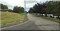
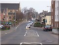
Edinburgh Road
The A8 Edinburgh Road at Easterhouse Road, looking east.
Image: © Thomas Nugent
Taken: 28 Jul 2021
0.04 miles
2
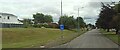
Edinburgh Road
The A8 Edinburgh Road at Easterhouse Road, looking east.
Image: © Thomas Nugent
Taken: 28 Jul 2021
0.05 miles
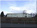
4
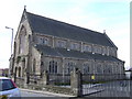
St John's Episcopal Church,Baillieston
Image: © emma mykytyn
Taken: 22 Mar 2008
0.08 miles
6
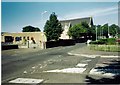
Baillieston, Buchanan Street
Looking north towards Swinton Road with St.Bridget's church on the left.
Image: © Robert Murray
Taken: 3 Apr 2005
0.13 miles
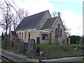
7
Baillieston, St. Bridgets Church
With social club hall in view.
Image: © Robert Murray
Taken: 16 Jun 2002
0.14 miles
8

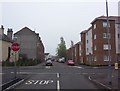
Baillieston, Buchanan Street
Swinton Road in the distance. Buchanan Street was the first street in the village of Baillieston after the Main Street and Church Street. Swinton Road was - and is - the road to Swinton.
Image: © Robert Murray
Taken: 19 Apr 2007
0.15 miles
9
Baillieston, Dyke Street
With the early Edwardian built tenements of Rhinsdale Terrace on the left and their modern equivalents built in the era of Blair.
Image: © Robert Murray
Taken: 4 Jun 2007
0.15 miles
10
Baillieston, Buchanan Gardens
Built in the 1990s on the site of Baillieston Secondary School.
Image: © Robert Murray
Taken: 4 Jun 2007
0.16 miles