IMAGES TAKEN NEAR TO
Rhindmuir Road, GLASGOW, G69 6AX
Introduction
This page details the photographs taken nearby to Rhindmuir Road, G69 6AX by members of the Geograph project.
The Geograph project started in 2005 with the aim of publishing, organising and preserving representative images for every square kilometre of Great Britain, Ireland and the Isle of Man.

There are currently over 7.5m images from over14,400 individuals and you can help contribute to the project by visiting https://www.geograph.org.uk
Image Map
Images are licensed for reuse under creativecommons.org/licenses/by-sa/2.0
Notes
- Clicking on the map will re-center to the selected point.
- The higher the marker number, the further away the image location is from the centre of the postcode.
Image Listing (20 Images Found)
Images are licensed for reuse under creativecommons.org/licenses/by-sa/2.0
Image
Details
Distance
1
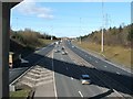
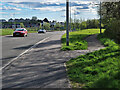
M8 viewed from Coatbridge Road
This part of the road is at Swinton, near Easterhouse.
Image: © Lairich Rig
Taken: 11 Mar 2005
0.10 miles
3
Pylon, motorway and church
The Category B Listed http://portal.historicenvironment.scot/designation/LB33672 Bargeddie Parish Church. Very much at odds with its surroundings of motorways and railway, viewed from the M8 motorway.
See also Image
Image: © Thomas Nugent
Taken: 23 Feb 2020
0.13 miles
4
Railway and motorway near Easterhouse
The line between Easterhouse and Blairhill, viewed from the M8 motorway.
Image: © Thomas Nugent
Taken: 23 Feb 2020
0.15 miles
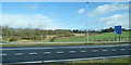
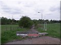
5
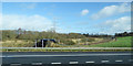
Footpaths and the A89 near Swinton Roundabout
Image: © wrobison
Taken: 20 Apr 2024
0.17 miles
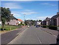
6
Manse Road, Bartonshill
This road between Bartonshill and Rhindmuir and Swinton was closed in 1977 when the M8 Monkland motorway was opened. This effectively severed Bargeddie parish church from much of its congregation.
Image: © Robert Murray
Taken: 13 May 2010
0.17 miles
7
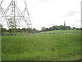
Fields at Ballieston Interchange
From eastbound M8. Base of pylon seen on left. Bargedie parish church can be seen in the background
Image: © John Firth
Taken: 13 May 2011
0.17 miles
8
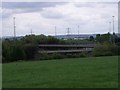
Baillieston Interchange
Where four major roads meet. The A8, A89, M8 and M73. Sometime called Scotland's 'Spaghetti Junction'.
Image: © Robert Murray
Taken: 13 May 2010
0.18 miles
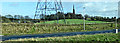
9
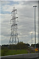
Glasgow City : Grassy Field & Pylon
A pylon seen alongside the M8 Motorway.
Image: © Lewis Clarke
Taken: 25 Apr 2016
0.18 miles
10
Railway near Easterhouse
The line between Easterhouse and Blairhill stations, viewed from the M8 motorway.
Image: © Thomas Nugent
Taken: 23 Feb 2020
0.19 miles