IMAGES TAKEN NEAR TO
Martin Crescent, GLASGOW, G69 6AJ
Introduction
This page details the photographs taken nearby to Martin Crescent, G69 6AJ by members of the Geograph project.
The Geograph project started in 2005 with the aim of publishing, organising and preserving representative images for every square kilometre of Great Britain, Ireland and the Isle of Man.

There are currently over 7.5m images from over14,400 individuals and you can help contribute to the project by visiting https://www.geograph.org.uk
Image Map (Loading...)


Getting Data...Please wait
Leaflet Map data © OpenStreetMap
Images are licensed for reuse under creativecommons.org/licenses/by-sa/2.0
Notes
- Clicking on the map will re-center to the selected point.
- The higher the marker number, the further away the image location is from the centre of the postcode.
Image Listing (46 Images Found)
Images are licensed for reuse under creativecommons.org/licenses/by-sa/2.0
Image
Details
Distance
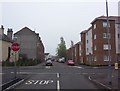
1
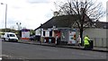
Main Street, Crosshill
The A89 seen from opposite Crosshill Park.
Image: © Richard Webb
Taken: 23 Apr 2012
0.06 miles
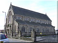
2
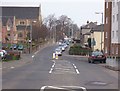
Baillieston, Buchanan Street
Looking north towards Swinton Road with St.Bridget's church on the left.
Image: © Robert Murray
Taken: 3 Apr 2005
0.06 miles

4
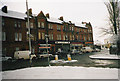
Baillieston, Main Street
The building is known locally as the 'Co Building' - reflecting its original ownership by the local Co-Operative Society.
Image: © Robert Murray
Taken: 27 Jan 2003
0.07 miles
5
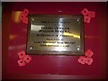
Flight Lt. William Reid VC
Tribute to a son of Baillieston in the library unveiled by the Lord Provost of Glasgow.
Image: © Robert Murray
Taken: 7 Feb 2009
0.07 miles
6
Baillieston Library
Opened 1968 and still going strong.
Image: © Robert Murray
Taken: 12 Jan 1989
0.07 miles
7
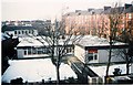
Baillieston Victoriana
Stables situated behind 'Caldwell's Building' in the Main Street. Since this photo was taken some of these out buildings have been demolished.
Image: © Robert Murray
Taken: 14 Feb 2003
0.07 miles
8

Baillieston, Buchanan Street
Swinton Road in the distance. Buchanan Street was the first street in the village of Baillieston after the Main Street and Church Street. Swinton Road was - and is - the road to Swinton.
Image: © Robert Murray
Taken: 19 Apr 2007
0.08 miles
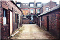
10
Baillieston, Dyke Street
With the early Edwardian built tenements of Rhinsdale Terrace on the left and their modern equivalents built in the era of Blair.
Image: © Robert Murray
Taken: 4 Jun 2007
0.09 miles