IMAGES TAKEN NEAR TO
Penzance Way, GLASGOW, G69 0PB
Introduction
This page details the photographs taken nearby to Penzance Way, G69 0PB by members of the Geograph project.
The Geograph project started in 2005 with the aim of publishing, organising and preserving representative images for every square kilometre of Great Britain, Ireland and the Isle of Man.

There are currently over 7.5m images from over14,400 individuals and you can help contribute to the project by visiting https://www.geograph.org.uk
Image Map
Images are licensed for reuse under creativecommons.org/licenses/by-sa/2.0
Notes
- Clicking on the map will re-center to the selected point.
- The higher the marker number, the further away the image location is from the centre of the postcode.
Image Listing (9 Images Found)
Images are licensed for reuse under creativecommons.org/licenses/by-sa/2.0
Image
Details
Distance
1
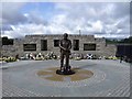
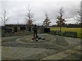
The Auchengeich Mining Disaster Memorial
Unveiled by the First Minister of Scotland Alex Salmond on 18th. September 2009 - the 50th. anniversary of the disaster when 47 colliers were killed in an underground fire on the same day in 1959.
The memorial replaces a smaller one which was situated at the same place next to the Auchengeich Miners Welfare.
See also Image which is the next square.
Image: © Robert Murray
Taken: 30 Sep 2009
0.17 miles
2
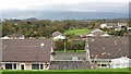
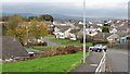
View out of Moodiesburn
Looking northwards from Stoneyetts Road over a landscape of mixed agriculture and a mining legacy.
Image: © Richard Webb
Taken: 14 Oct 2011
0.20 miles
4
Auchengeich mining disaster memorial
A fire at Auchengeich colliery on 18th September 1959 tragically claimed the lives of 47 men. This memorial was unveiled on the 50th anniversary of the disaster.
Image: © Euan Nelson
Taken: 18 Feb 2018
0.22 miles
5
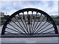
Auchengeich Memorial
The full view with the old pithead wheel from the colliery which was nearby
See also Image which is in the next square.
Image: © Robert Murray
Taken: 30 Sep 2009
0.22 miles
7
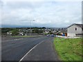
Moodiesburn
Looking roughly NE across the suburb from Stoneyetts Road.
Image: © Stephen Sweeney
Taken: 2 Aug 2011
0.23 miles
8
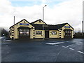
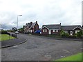
Auchengeich Miners Welfare Social Club
At the corner of Gartferry Road and Auchengeich Road, Moodiesburn.
Image: © G Laird
Taken: 2 Jan 2014
0.23 miles