IMAGES TAKEN NEAR TO
Westdale Drive, GLASGOW, G69 0NR
Introduction
This page details the photographs taken nearby to Westdale Drive, G69 0NR by members of the Geograph project.
The Geograph project started in 2005 with the aim of publishing, organising and preserving representative images for every square kilometre of Great Britain, Ireland and the Isle of Man.

There are currently over 7.5m images from over14,400 individuals and you can help contribute to the project by visiting https://www.geograph.org.uk
Image Map
Images are licensed for reuse under creativecommons.org/licenses/by-sa/2.0
Notes
- Clicking on the map will re-center to the selected point.
- The higher the marker number, the further away the image location is from the centre of the postcode.
Image Listing (8 Images Found)
Images are licensed for reuse under creativecommons.org/licenses/by-sa/2.0
Image
Details
Distance
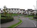
1

Glen Iris, Moodiesburn
A smart looking new housing scheme on the edge of Moodiesburn
Image: © Chris Upson
Taken: 19 Aug 2006
0.04 miles
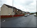
2
Westdale Drive
Recent housing development in Moodiesburn.
Image: © Richard Webb
Taken: 14 Oct 2011
0.05 miles
4
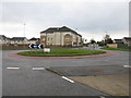
Entering Moodiesburn from the east
Looking along Gartferry Road.
Image: © G Laird
Taken: 2 Jan 2014
0.19 miles
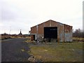
5

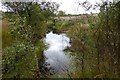
Moodiesburn Moss Litter Works
Now lying derelict. The peat was cut from the muir to the southeast
and brought on wagons by a tramway to here. There were several buildings
on the site when peat was being cultivated, this being the only one to survive.
Image: © Texas Radio and The Big Beat
Taken: 23 Jan 2010
0.21 miles
6
Moodiesburn Moss Litter Works
Now derelict. See also www.geograph.org.uk/photo/1674765
Image: © Texas Radio and The Big Beat
Taken: 23 Jan 2010
0.21 miles
8

St Michael's Primary School
In Moodiesburn, near Glasgow.
Image: © Stephen Sweeney
Taken: 2 Aug 2011
0.25 miles