IMAGES TAKEN NEAR TO
Knockmilly Place, GLASGOW, G69 0LD
Introduction
This page details the photographs taken nearby to Knockmilly Place, G69 0LD by members of the Geograph project.
The Geograph project started in 2005 with the aim of publishing, organising and preserving representative images for every square kilometre of Great Britain, Ireland and the Isle of Man.

There are currently over 7.5m images from over14,400 individuals and you can help contribute to the project by visiting https://www.geograph.org.uk
Image Map
Images are licensed for reuse under creativecommons.org/licenses/by-sa/2.0
Notes
- Clicking on the map will re-center to the selected point.
- The higher the marker number, the further away the image location is from the centre of the postcode.
Image Listing (6 Images Found)
Images are licensed for reuse under creativecommons.org/licenses/by-sa/2.0
Image
Details
Distance
1
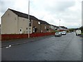
Entering Moodiesburn from the east
Looking along Gartferry Road.
Image: © G Laird
Taken: 2 Jan 2014
0.05 miles
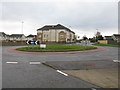
2
Westdale Drive
Recent housing development in Moodiesburn.
Image: © Richard Webb
Taken: 14 Oct 2011
0.09 miles
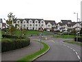
3
Glen Iris, Moodiesburn
A smart looking new housing scheme on the edge of Moodiesburn
Image: © Chris Upson
Taken: 19 Aug 2006
0.11 miles
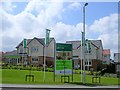
4
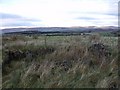
Remains of East Barrs Farm
With the Campsie Hills on the horizon.
Image: © Robert Murray
Taken: 16 Dec 2009
0.20 miles
5
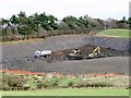
New open cast mine
Viewed from the upper deck of an X3 bus shows exposed coal seam. This dig has been well hidden from Gartferry Road by a recently built high bund. Access to and from it is by way of the new motorway work site. One has to wonder if the surveyors discovered a virgin seam and it was decided to extract it by open cast method.
Image: © Robert Murray
Taken: 16 Dec 2009
0.22 miles