IMAGES TAKEN NEAR TO
Rowan Court, G69 0FG
Introduction
This page details the photographs taken nearby to Rowan Court, G69 0FG by members of the Geograph project.
The Geograph project started in 2005 with the aim of publishing, organising and preserving representative images for every square kilometre of Great Britain, Ireland and the Isle of Man.

There are currently over 7.5m images from over14,400 individuals and you can help contribute to the project by visiting https://www.geograph.org.uk
Image Map
Images are licensed for reuse under creativecommons.org/licenses/by-sa/2.0
Notes
- Clicking on the map will re-center to the selected point.
- The higher the marker number, the further away the image location is from the centre of the postcode.
Image Listing (3 Images Found)
Images are licensed for reuse under creativecommons.org/licenses/by-sa/2.0
Image
Details
Distance
1
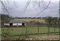
Stoneyetts Bowling Club near Moodiesburn
Formerly linked with Stoneyetts Hospital which doesn't exist any more
Image: © Chris Upson
Taken: 25 Feb 2006
0.11 miles
2
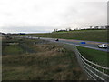
M80 at Moodiesburn
The final alignment of the M80 at this point is slightly north of the proposed line in the OS map.
Image: © G Laird
Taken: 2 Jan 2014
0.11 miles