IMAGES TAKEN NEAR TO
Laverock Terrace, GLASGOW, G69 0AZ
Introduction
This page details the photographs taken nearby to Laverock Terrace, G69 0AZ by members of the Geograph project.
The Geograph project started in 2005 with the aim of publishing, organising and preserving representative images for every square kilometre of Great Britain, Ireland and the Isle of Man.

There are currently over 7.5m images from over14,400 individuals and you can help contribute to the project by visiting https://www.geograph.org.uk
Image Map
Images are licensed for reuse under creativecommons.org/licenses/by-sa/2.0
Notes
- Clicking on the map will re-center to the selected point.
- The higher the marker number, the further away the image location is from the centre of the postcode.
Image Listing (5 Images Found)
Images are licensed for reuse under creativecommons.org/licenses/by-sa/2.0
Image
Details
Distance

2
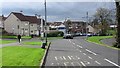
The shops, Moodiesburn
Looking down Glenmanor Avenue towards a row of shops.
Image: © Richard Webb
Taken: 14 Oct 2011
0.18 miles
5
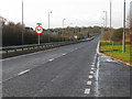
A80 (Cumbernauld Road) at Moodiesburn
Prior to the opening of the M80, this was a very busy road from Glasgow to Stirling.
Image: © G Laird
Taken: 8 Jan 2014
0.24 miles