IMAGES TAKEN NEAR TO
Cardowan Drive, GLASGOW, G68 9PB
Introduction
This page details the photographs taken nearby to Cardowan Drive, G68 9PB by members of the Geograph project.
The Geograph project started in 2005 with the aim of publishing, organising and preserving representative images for every square kilometre of Great Britain, Ireland and the Isle of Man.

There are currently over 7.5m images from over14,400 individuals and you can help contribute to the project by visiting https://www.geograph.org.uk
Image Map
Images are licensed for reuse under creativecommons.org/licenses/by-sa/2.0
Notes
- Clicking on the map will re-center to the selected point.
- The higher the marker number, the further away the image location is from the centre of the postcode.
Image Listing (3 Images Found)
Images are licensed for reuse under creativecommons.org/licenses/by-sa/2.0
Image
Details
Distance
1
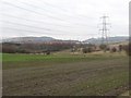
Farmland, Blackwood
Land currently on the edge of Cumbernauld. Much of the ground here is low lying and marshy, but a crop has been planted here.
Image: © Richard Webb
Taken: 4 Mar 2011
0.15 miles
2
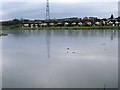
Broadwood Loch and Blackwood
The objects lying on the surface are lying there and not floating as the loch was still by this date frozen which was its continuous state since mid December 2009.
Image: © Robert Murray
Taken: 6 Feb 2010
0.23 miles
3
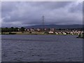
Blackwood and the Campsies
From across Broadwood Loch.
Image: © Robert Murray
Taken: 24 Sep 2009
0.23 miles