IMAGES TAKEN NEAR TO
Orchardton Road, GLASGOW, G68 9LB
Introduction
This page details the photographs taken nearby to Orchardton Road, G68 9LB by members of the Geograph project.
The Geograph project started in 2005 with the aim of publishing, organising and preserving representative images for every square kilometre of Great Britain, Ireland and the Isle of Man.

There are currently over 7.5m images from over14,400 individuals and you can help contribute to the project by visiting https://www.geograph.org.uk
Image Map
Images are licensed for reuse under creativecommons.org/licenses/by-sa/2.0
Notes
- Clicking on the map will re-center to the selected point.
- The higher the marker number, the further away the image location is from the centre of the postcode.
Image Listing (18 Images Found)
Images are licensed for reuse under creativecommons.org/licenses/by-sa/2.0
Image
Details
Distance
1
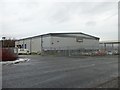
Industrial property in Axis Park
Owned by a company called Knowhow, which ironically enough I can't find anything out about! I think it's to do with distribution for Currys and PC World - thanks to David Clark for the info.
Image: © Stephen Sweeney
Taken: 20 Dec 2011
0.06 miles

3
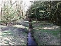
Drainage channel
This escapes from Orchardton pond and eventually deposits its flow into a marshy area.
Image: © Robert Murray
Taken: 10 Apr 2010
0.10 miles
4
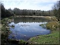
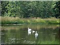
Orchardton Pond
Mammy & daddy swan with cygnet.
Image: © Robert Murray
Taken: 23 Jul 2011
0.10 miles
5
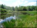
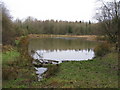
Orchardton Pond
Situated within the woods to the west of Broadwood Loch.
Image: © Robert Murray
Taken: 10 Apr 2010
0.10 miles
7
Orchardton Pond
Orchardton Pond is sheltered, never dries out and, being shallow, is relatively warm and light in summer. These are perfect growing conditions for many aquatic plants.
Image: © G Laird
Taken: 5 Jan 2014
0.11 miles
8
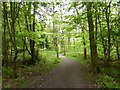
Broadwood Nature Reserve
Path through the Drum Mains forest.
Image: © Robert Murray
Taken: 18 May 2014
0.16 miles
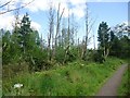
9
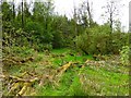
Broadwood Nature Reserve
Some devastation caused by high winds.
Image: © Robert Murray
Taken: 18 May 2014
0.18 miles
10
Broadwood Loch, nature reserve
Dead trees and new growth.
Image: © Robert Murray
Taken: 23 Jul 2011
0.19 miles