IMAGES TAKEN NEAR TO
Old Tower Road, GLASGOW, G68 9GE
Introduction
This page details the photographs taken nearby to Old Tower Road, G68 9GE by members of the Geograph project.
The Geograph project started in 2005 with the aim of publishing, organising and preserving representative images for every square kilometre of Great Britain, Ireland and the Isle of Man.

There are currently over 7.5m images from over14,400 individuals and you can help contribute to the project by visiting https://www.geograph.org.uk
Image Map
Images are licensed for reuse under creativecommons.org/licenses/by-sa/2.0
Notes
- Clicking on the map will re-center to the selected point.
- The higher the marker number, the further away the image location is from the centre of the postcode.
Image Listing (7 Images Found)
Images are licensed for reuse under creativecommons.org/licenses/by-sa/2.0
Image
Details
Distance
1
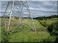
Pylon and Dullatur Golf Course, Cumbernauld
Image: © Chris Upson
Taken: 13 Aug 2006
0.17 miles
2
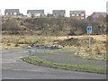
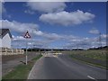
Expanding Cumbernauld: Smithstone
My recent map did not have this road on it, nor the roundabout to nowhere on former farmland. The ground here awaits housing development on a site convenient for Croy railway station on the busiest of the four Edinburgh-Glasgow railways.
Image: © Richard Webb
Taken: 4 Mar 2011
0.18 miles
3
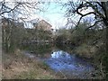
Smithston Quarry, Cumbernauld
This quarry was worked when the area never had an 'E' at the end of the name.
Image: © Robert Murray
Taken: 21 Apr 2010
0.19 miles
4
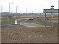
New road, Smithstone
Access road to a largely yet to be built housing development near Croy station.
Image: © Richard Webb
Taken: 4 Mar 2011
0.19 miles
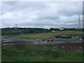
5
Roundabout, Smithstone
Smithstone is a fairly new suburb of Cumbernauld and the development at this roundabout is the latest addition.
Image: © Robert Murray
Taken: 21 Apr 2010
0.22 miles
6
Earthmovers near Croy railway station
Viewed from an Edinburgh bound train.
Image: © Thomas Nugent
Taken: 11 Jul 2010
0.23 miles
7
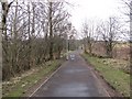
Path to Craigmarloch
On a 1970s 1:50,000 Ordnance Survey map this is shown as a rural minor road, far from Cumbernauld. The new town has expanded and now has a new purpose built road network. The old road has become a footpath linking Craigmarloch with Croy railway station.
Image: © Richard Webb
Taken: 4 Mar 2011
0.24 miles