IMAGES TAKEN NEAR TO
Southfield Road, GLASGOW, G68 9DZ
Introduction
This page details the photographs taken nearby to Southfield Road, G68 9DZ by members of the Geograph project.
The Geograph project started in 2005 with the aim of publishing, organising and preserving representative images for every square kilometre of Great Britain, Ireland and the Isle of Man.

There are currently over 7.5m images from over14,400 individuals and you can help contribute to the project by visiting https://www.geograph.org.uk
Image Map
Images are licensed for reuse under creativecommons.org/licenses/by-sa/2.0
Notes
- Clicking on the map will re-center to the selected point.
- The higher the marker number, the further away the image location is from the centre of the postcode.
Image Listing (13 Images Found)
Images are licensed for reuse under creativecommons.org/licenses/by-sa/2.0
Image
Details
Distance
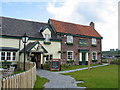
1
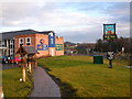
Red Deer Innkeepers Lodge, Cumbernauld.
Image: © Johnny Durnan
Taken: 4 Dec 2005
0.12 miles
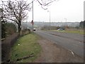
4
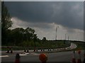
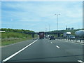
Turn off on to the A 73
Under heavy roadworks.
Image: © Peter Bond
Taken: 23 May 2010
0.18 miles
5
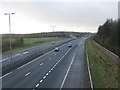
M80 at Cumbernauld
Looking south west from a footbridge towards Junction 5, the intersection with the A73 to Airdrie.
Image: © G Laird
Taken: 8 Jan 2014
0.19 miles
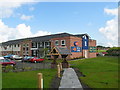
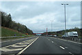
8
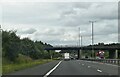
M80, Auchenkilns
The slip road on the left is from the Auchenkilns junction (4a). The red bridge ahead is to the same, or very similar, design as Image] which is a little further south.
Image: © David Dixon
Taken: 23 Oct 2011
0.20 miles
10
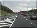
Cumbernauld footbridge over m80
Over M80 just east of M80 junction 5 looking east
Image: © John Firth
Taken: 13 May 2012
0.20 miles