IMAGES TAKEN NEAR TO
Balloch Holdings, GLASGOW, G68 9AT
Introduction
This page details the photographs taken nearby to Balloch Holdings, G68 9AT by members of the Geograph project.
The Geograph project started in 2005 with the aim of publishing, organising and preserving representative images for every square kilometre of Great Britain, Ireland and the Isle of Man.

There are currently over 7.5m images from over14,400 individuals and you can help contribute to the project by visiting https://www.geograph.org.uk
Image Map
Images are licensed for reuse under creativecommons.org/licenses/by-sa/2.0
Notes
- Clicking on the map will re-center to the selected point.
- The higher the marker number, the further away the image location is from the centre of the postcode.
Image Listing (5 Images Found)
Images are licensed for reuse under creativecommons.org/licenses/by-sa/2.0
Image
Details
Distance
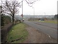
1
Broadwood Farm, Cumbernauld
Restaurant at Black O'Hill roundabout.
Image: © G Laird
Taken: 8 Jan 2014
0.16 miles
2
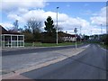
Balloch Loop Road,Cumbernauld
Smiddy pub in the distance.
Image: © Robert Murray
Taken: 21 Apr 2010
0.18 miles
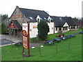
3
The Smiddy
Public house and shop, Balloch, Cumbernauld.
Image: © Richard Webb
Taken: 4 Mar 2011
0.19 miles
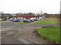
4
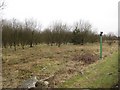
Young woodland
Near the Back O' Wood roundabout. The pipe with the cowling is there to disperse methane, this may have been a former groundfill site.
Image: © Richard Webb
Taken: 4 Mar 2011
0.20 miles