IMAGES TAKEN NEAR TO
Broomknowe, GLASGOW, G68 9AQ
Introduction
This page details the photographs taken nearby to Broomknowe, G68 9AQ by members of the Geograph project.
The Geograph project started in 2005 with the aim of publishing, organising and preserving representative images for every square kilometre of Great Britain, Ireland and the Isle of Man.

There are currently over 7.5m images from over14,400 individuals and you can help contribute to the project by visiting https://www.geograph.org.uk
Image Map
Images are licensed for reuse under creativecommons.org/licenses/by-sa/2.0
Notes
- Clicking on the map will re-center to the selected point.
- The higher the marker number, the further away the image location is from the centre of the postcode.
Image Listing (6 Images Found)
Images are licensed for reuse under creativecommons.org/licenses/by-sa/2.0
Image
Details
Distance
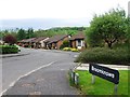
3
Path into Cumbernauld Community Park
At the road into Eastfield Cemetery.
Image: © Stephen Sweeney
Taken: 16 Apr 2014
0.14 miles
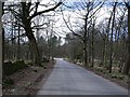
4
Avenue, Eastfield Cemetery
Lined both sides with young cherry blossom trees.
Image: © Texas Radio and The Big Beat
Taken: 24 Apr 2010
0.15 miles
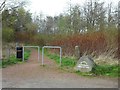
5
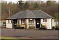
Eastfield Cemetery Lavatorial Facilities
Image: © Texas Radio and The Big Beat
Taken: 24 Apr 2010
0.18 miles
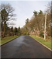
6
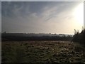
Airdriehead farm, Cumbernauld community park
Image: © carrickstone emily
Taken: 5 Nov 2011
0.21 miles