IMAGES TAKEN NEAR TO
Langhill Drive, GLASGOW, G68 9AP
Introduction
This page details the photographs taken nearby to Langhill Drive, G68 9AP by members of the Geograph project.
The Geograph project started in 2005 with the aim of publishing, organising and preserving representative images for every square kilometre of Great Britain, Ireland and the Isle of Man.

There are currently over 7.5m images from over14,400 individuals and you can help contribute to the project by visiting https://www.geograph.org.uk
Image Map
Images are licensed for reuse under creativecommons.org/licenses/by-sa/2.0
Notes
- Clicking on the map will re-center to the selected point.
- The higher the marker number, the further away the image location is from the centre of the postcode.
Image Listing (5 Images Found)
Images are licensed for reuse under creativecommons.org/licenses/by-sa/2.0
Image
Details
Distance
1
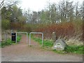
Path into Cumbernauld Community Park
At the road into Eastfield Cemetery.
Image: © Stephen Sweeney
Taken: 16 Apr 2014
0.10 miles
4
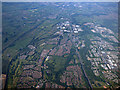
Cumbernauld from the air
Looking north over Balloch along the line of the M80 motorway.
Image: © Thomas Nugent
Taken: 5 Jun 2016
0.20 miles
5
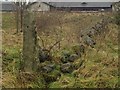
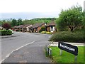
Old farm entrance, Craighalbert, Cumbernauld
This is perhaps the old entrance to Craighalbert farm or workers cottages. Old stone Dyke walls surround the area.
Image: © carrickstone emily
Taken: 6 Jan 2012
0.22 miles