IMAGES TAKEN NEAR TO
Duncan McIntosh Road, GLASGOW, G68 0HH
Introduction
This page details the photographs taken nearby to Duncan McIntosh Road, G68 0HH by members of the Geograph project.
The Geograph project started in 2005 with the aim of publishing, organising and preserving representative images for every square kilometre of Great Britain, Ireland and the Isle of Man.

There are currently over 7.5m images from over14,400 individuals and you can help contribute to the project by visiting https://www.geograph.org.uk
Image Map
Images are licensed for reuse under creativecommons.org/licenses/by-sa/2.0
Notes
- Clicking on the map will re-center to the selected point.
- The higher the marker number, the further away the image location is from the centre of the postcode.
Image Listing (11 Images Found)
Images are licensed for reuse under creativecommons.org/licenses/by-sa/2.0
Image
Details
Distance
1

Cumbernauld Airport
A one runway airfield really but important for its air traffic beacon. It also hosts two flying schools.
This little airport has a place in history in that the helicopter in 'Helicopter Sunday' took off from here, took a bearing to Motherwell but filed a new flight plan to Edinburgh amid scenes of devastation at the former and unprecedented jubilation at the latter.
Image: © Robert Murray
Taken: 28 Apr 2010
0.02 miles
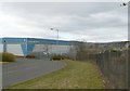
2
Napier Road, Wardpark Industrial Estate
Napier Road is the orbital road for the northern part of Wardpark industrial estate.
Image: © Richard Webb
Taken: 14 Oct 2011
0.08 miles
3
Cumbernauld Airport
Small airport near Cumbernauld off the Ward Park industrial estate.
Image: © Jim Bain
Taken: 26 Feb 2006
0.09 miles
5
Cumbernauld Airport, apron
The weekenders lying and waiting.
Image: © Robert Murray
Taken: 28 Apr 2010
0.12 miles
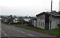
6

Cumbernauld Airport buildings
Probably maintenance. Of interest is the fuelage of some kind of aircraft, looks a bit old fashioned.
Image: © Robert Murray
Taken: 28 Apr 2010
0.14 miles
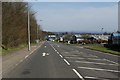
7
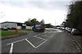
Napier Road
A street cleaning vehicle is working at keeping mud off the road at the entrance to a construction site by the Scottish Power offices.
Image: © Richard Webb
Taken: 14 Oct 2011
0.14 miles
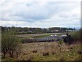
8
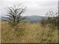
Land awaiting development, Cumbernauld
Rough ground between the airport and the Scottish Power offices off Napier Road. There was building work in progress nearby.
Image: © Richard Webb
Taken: 14 Oct 2011
0.16 miles
9
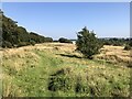
Path beside the Antonine Wall
Former farmland which appears to be lime rich, quite a downland feel to it. The wall is in the trees to the left. Lovely spot and so close to industrial Cumbernauld.
Image: © Richard Webb
Taken: 6 Sep 2024
0.19 miles
10
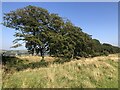
Antonine Wall
A well preserved stretch of the wall.
Image: © Richard Webb
Taken: 6 Sep 2024
0.20 miles