IMAGES TAKEN NEAR TO
Calderstone Drive, GLASGOW, G68 0GQ
Introduction
This page details the photographs taken nearby to Calderstone Drive, G68 0GQ by members of the Geograph project.
The Geograph project started in 2005 with the aim of publishing, organising and preserving representative images for every square kilometre of Great Britain, Ireland and the Isle of Man.

There are currently over 7.5m images from over14,400 individuals and you can help contribute to the project by visiting https://www.geograph.org.uk
Image Map
Images are licensed for reuse under creativecommons.org/licenses/by-sa/2.0
Notes
- Clicking on the map will re-center to the selected point.
- The higher the marker number, the further away the image location is from the centre of the postcode.
Image Listing (3 Images Found)
Images are licensed for reuse under creativecommons.org/licenses/by-sa/2.0
Image
Details
Distance
1
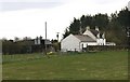
North Muirhead Farm
One of Cumbernauld's original farms.
Many were demolished and built over as the new town
developed but this one has survived.
Image: © Texas Radio and The Big Beat
Taken: 22 Apr 2010
0.13 miles
2

Dullatur Golf Course
Dullatur Golf Course, November 27 2010
Image: © Simon Walsh
Taken: 26 Nov 2010
0.18 miles
3
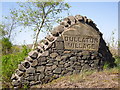
Dullatur Village
This large sign can be found at the entrance to Dullatur Village from the approach from Cumbernauld.
Image: © Stevie Spiers
Taken: 11 May 2009
0.22 miles