IMAGES TAKEN NEAR TO
Dunning Drive, GLASGOW, G68 0FN
Introduction
This page details the photographs taken nearby to Dunning Drive, G68 0FN by members of the Geograph project.
The Geograph project started in 2005 with the aim of publishing, organising and preserving representative images for every square kilometre of Great Britain, Ireland and the Isle of Man.

There are currently over 7.5m images from over14,400 individuals and you can help contribute to the project by visiting https://www.geograph.org.uk
Image Map
Images are licensed for reuse under creativecommons.org/licenses/by-sa/2.0
Notes
- Clicking on the map will re-center to the selected point.
- The higher the marker number, the further away the image location is from the centre of the postcode.
Image Listing (18 Images Found)
Images are licensed for reuse under creativecommons.org/licenses/by-sa/2.0
Image
Details
Distance
1
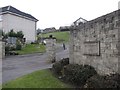
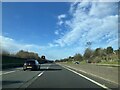
Dunning Drive
A residential street with fine views of the M80. The developer's name can be seen on the wall, but a street sign calls it Dunning Drive.
Image: © Richard Webb
Taken: 4 Mar 2011
0.03 miles
4
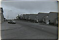
Roadside, Cumbernauld Village
Looking west along Roadside from Smithyends. Photo taken circa 1983
Image: © coughlan
Taken: Unknown
0.15 miles
6

Smithyends, Cumbernauld Village
Photo taken circa 1983
Image: © coughlan
Taken: Unknown
0.19 miles
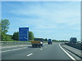
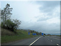
7

Tunnel Vision
Tunnel under the A80 to Cumbernauld Village
Image: © Chris Upson
Taken: 19 Aug 2006
0.19 miles
8
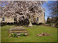
Churchyard, Cumbernauld Old Parish Church
The original foundation was late 12th-early 13th century; the present church building was erected in 1650, and has had several later additions such as the North Aisle, additional storey, galleries with exterior stairs and tall south windows. The earliest inscription in the graveyard is 1625.
Image: © Janet MacDonald
Taken: 4 Apr 2007
0.20 miles
9

Ardenlea House
This building was used as the library for Cumbernauld Village until it was replaced by a mobile library. Ardenlea House was going to become a children's nursery school but that hasn't happened yet and remains at the moment unused. It would make a fantastic family home or children's nursery as it has a large garden that could be something special with a little bit of work.
Image: © Stevie Spiers
Taken: 13 May 2009
0.21 miles
10

Ardenlea House (rear)
Rear view of www.geograph.org.uk/photo/1303149
Image: © Texas Radio and The Big Beat
Taken: 4 Feb 2010
0.21 miles