IMAGES TAKEN NEAR TO
Napier Park, GLASGOW, G68 0BH
Introduction
This page details the photographs taken nearby to Napier Park, G68 0BH by members of the Geograph project.
The Geograph project started in 2005 with the aim of publishing, organising and preserving representative images for every square kilometre of Great Britain, Ireland and the Isle of Man.

There are currently over 7.5m images from over14,400 individuals and you can help contribute to the project by visiting https://www.geograph.org.uk
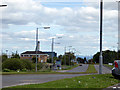
Image Map
Images are licensed for reuse under creativecommons.org/licenses/by-sa/2.0
Notes
- Clicking on the map will re-center to the selected point.
- The higher the marker number, the further away the image location is from the centre of the postcode.
Image Listing (13 Images Found)
Images are licensed for reuse under creativecommons.org/licenses/by-sa/2.0
Image
Details
Distance
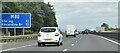
1
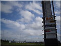
Westway Retail Park sign in Wardpark, Cumbernauld
Image: © Stevie Spiers
Taken: 17 May 2009
0.05 miles
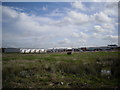
2
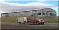
Westway Retail Park, Wardpark, Cumbernauld
Image: © Elliott Simpson
Taken: 2 Dec 2012
0.06 miles
4
Westway Retail Park, Wardpark, Cumbernauld
Image: © Stevie Spiers
Taken: 17 May 2009
0.08 miles
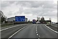
6
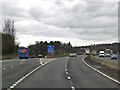
Forest Road / A80
The point where the A80 crosses over Forest Road.
The bridge carrying the A80 is being upgraded (widened)
along with the dual-carriageway.
Image: © Texas Radio and The Big Beat
Taken: 2 Apr 2010
0.13 miles
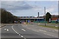
8

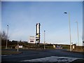
North Lanarkshire : Briggs Equipment UK
Looking from the M80 to a warehouse.
Image: © Lewis Clarke
Taken: 25 Apr 2016
0.17 miles