IMAGES TAKEN NEAR TO
Craigelvan Avenue, GLASGOW, G67 4SB
Introduction
This page details the photographs taken nearby to Craigelvan Avenue, G67 4SB by members of the Geograph project.
The Geograph project started in 2005 with the aim of publishing, organising and preserving representative images for every square kilometre of Great Britain, Ireland and the Isle of Man.

There are currently over 7.5m images from over14,400 individuals and you can help contribute to the project by visiting https://www.geograph.org.uk
Image Map
Images are licensed for reuse under creativecommons.org/licenses/by-sa/2.0
Notes
- Clicking on the map will re-center to the selected point.
- The higher the marker number, the further away the image location is from the centre of the postcode.
Image Listing (27 Images Found)
Images are licensed for reuse under creativecommons.org/licenses/by-sa/2.0
Image
Details
Distance
1
Condorrat, Moss Water
The burn flows as you look towards the north-west. It goes on to empty into Broadwood Loch after leaving which by an overflow shaft it joins the Board Burn and eventually discharging into the Kelvin north-west of Twechar.
Image: © Robert Murray
Taken: 25 Apr 2011
0.06 miles
2
Condorrat, Moss Water
As it emerges from the culvert taking it under Main Road. This is a curious burn as its source is within a few metres of the Luggie Water - from which it flows away from.
It seems indicative of something that the burn has been dammed here stopping its natural flow. Further information to follow.
Image: © Robert Murray
Taken: 25 Apr 2011
0.07 miles
3
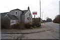
Dalshannon Farm Restaurant (unoccupied)
Image: © Texas Radio and The Big Beat
Taken: 8 Mar 2010
0.08 miles
4
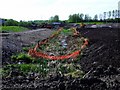
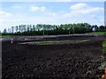
Construction site, Dalshannon
Ground work in progress next to the M80 construction.
Image: © Richard Webb
Taken: 4 Mar 2011
0.08 miles
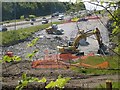
5
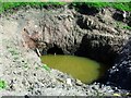
Condorrat, motorway works
A new suds pond dug to take surface water from the M80 (under construction) it remains to be seen where this water will go after it filters through this pond.
Image: © Robert Murray
Taken: 25 Apr 2011
0.10 miles
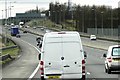
6
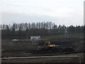
Earthworks at Westfield
A80/M80 online upgrade works.
Image: © Robert Murray
Taken: 12 Jun 2009
0.11 miles
8
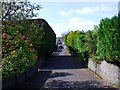
Condorrat, lane
Joins Main Road and Rosehill Drive.
Image: © Robert Murray
Taken: 25 Apr 2011
0.15 miles
9

Luggie Water at old mill lade
It is at this bend in the river that a dam diverted a flow into the lade that fed Woodmill (corn) a quarter of a mile downstream.
Image: © Robert Murray
Taken: 10 Dec 2009
0.16 miles
10
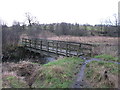
Footbridge over the Luggie Water
Just outside Condorrat.
Image: © G Laird
Taken: 5 Jan 2014
0.17 miles