IMAGES TAKEN NEAR TO
Myvot Road, GLASGOW, G67 4NA
Introduction
This page details the photographs taken nearby to Myvot Road, G67 4NA by members of the Geograph project.
The Geograph project started in 2005 with the aim of publishing, organising and preserving representative images for every square kilometre of Great Britain, Ireland and the Isle of Man.

There are currently over 7.5m images from over14,400 individuals and you can help contribute to the project by visiting https://www.geograph.org.uk
Image Map
Images are licensed for reuse under creativecommons.org/licenses/by-sa/2.0
Notes
- Clicking on the map will re-center to the selected point.
- The higher the marker number, the further away the image location is from the centre of the postcode.
Image Listing (15 Images Found)
Images are licensed for reuse under creativecommons.org/licenses/by-sa/2.0
Image
Details
Distance
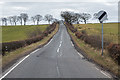
1
Myvot Avenue, Condorrat, Cumbernauld
Image: © Stephen Sweeney
Taken: 17 Jul 2012
0.05 miles

4
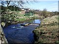
Luggie Water at B802 bridge
Lots of evidence of a much higher water level the previous weekend
Image: © Jim Smillie
Taken: 14 Oct 2023
0.11 miles
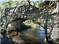
5
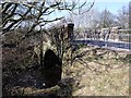
Luggie Bridge
Takes the Airdrie - Condorrat road, B802.
Image: © Robert Murray
Taken: 12 Apr 2010
0.11 miles
6
Sepa monitoring station, Luggie Water
South of Condorrat.
Image: © Robert Murray
Taken: 12 Apr 2010
0.12 miles
7
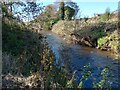
Luggie Water
Just downstream of B802 bridge
Image: © Jim Smillie
Taken: 14 Oct 2023
0.12 miles
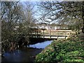
8
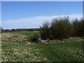
Footbridge in the fields
Connecting the meadows south of Condorrat.
Image: © Robert Murray
Taken: 12 Apr 2010
0.14 miles
9
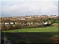
Looking towards Condorrat from North Myvot
Image: © Texas Radio and The Big Beat
Taken: 17 Jan 2010
0.14 miles