IMAGES TAKEN NEAR TO
Thorniecroft Place, GLASGOW, G67 4JU
Introduction
This page details the photographs taken nearby to Thorniecroft Place, G67 4JU by members of the Geograph project.
The Geograph project started in 2005 with the aim of publishing, organising and preserving representative images for every square kilometre of Great Britain, Ireland and the Isle of Man.

There are currently over 7.5m images from over14,400 individuals and you can help contribute to the project by visiting https://www.geograph.org.uk
Image Map
Images are licensed for reuse under creativecommons.org/licenses/by-sa/2.0
Notes
- Clicking on the map will re-center to the selected point.
- The higher the marker number, the further away the image location is from the centre of the postcode.
Image Listing (7 Images Found)
Images are licensed for reuse under creativecommons.org/licenses/by-sa/2.0
Image
Details
Distance
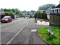
2
Outskirts of Cumbernauld
The newer suburbs of Cumbernauld boast rather more conventional architecture than does the centre. Sensibly, they have avoided building right on the river floodplain, which is a playing field.
Image: © Anne Burgess
Taken: 25 Aug 2015
0.16 miles
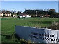
4
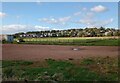
Rugby pitch with Condorrat beyond
Home of Cumbernauld Rugby Club
Image: © Jim Smillie
Taken: 14 Oct 2023
0.20 miles
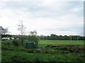
5
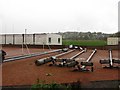
Cumbernauld Rugby Club
Recumbent floodlights.
Image: © Richard Webb
Taken: 18 Oct 2010
0.21 miles
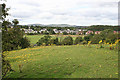
6
Auchenkilns Holdings
And the fields of Cumbernauld Rugby Club in the foreground.
Image: © Robert Murray
Taken: 16 Oct 2009
0.22 miles
7
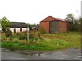
Shed, Chapelton Road
Industrial buildings by Cumbernauld Rugby Club.
Image: © Richard Webb
Taken: 18 Oct 2010
0.24 miles