IMAGES TAKEN NEAR TO
Cumbernauld Road, GLASGOW, G67 4HW
Introduction
This page details the photographs taken nearby to Cumbernauld Road, G67 4HW by members of the Geograph project.
The Geograph project started in 2005 with the aim of publishing, organising and preserving representative images for every square kilometre of Great Britain, Ireland and the Isle of Man.

There are currently over 7.5m images from over14,400 individuals and you can help contribute to the project by visiting https://www.geograph.org.uk
Image Map
Images are licensed for reuse under creativecommons.org/licenses/by-sa/2.0
Notes
- Clicking on the map will re-center to the selected point.
- The higher the marker number, the further away the image location is from the centre of the postcode.
Image Listing (29 Images Found)
Images are licensed for reuse under creativecommons.org/licenses/by-sa/2.0
Image
Details
Distance
1
M80 new bridge over Luggie Water
This is a completely new bridge. The previous crossing over the river by the A80 was demolished as part of the road upgrade.
The burn joining the Luggie from the left is the Mollins Burn.
Image: © Robert Murray
Taken: 25 Apr 2011
0.05 miles
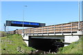

4
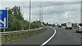
M80 Junction 4
Approaching junction 4 on the southbound M80 (formerly A80)
Image: © David Dixon
Taken: 27 Oct 2011
0.06 miles
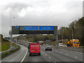
5

Overhead sign Gantry, M80/M73 Junction
A typical “Glasgow-type” sign gantry with the following distinctive elements:
• Near and offside support legs (basically 2 rectangular hollow sections with base plates to allow connections to the foundations)
• A Main Frame (made up of rectangular hollow sections) - Over clad on the front and rear.
• A Sub Frame (made up of smaller hollow sections and welded to main frame).
• A Sign Face - acrylic sheets hung from the front of the sub frame over its full height.
• Internal Electrics - sign lighting provided through the use of several dozen fluorescent battens.
Gantries of this type were first erected as part of the construction of the Kingston Bridge and its approach roads in 1970 and they are now a familiar sight on the motorway network around Glasgow.
Image: © David Dixon
Taken: 28 Mar 2014
0.06 miles
6
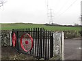
Power lines, Mollinsburn
View with my back to the motorway construction works at the entrance of Badenheath Park.
Image: © Richard Webb
Taken: 4 Mar 2011
0.06 miles
8
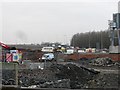
Motorway construction, Mollinsburn
Latter stages of work on upgrading the A80 between Haggs and Mollinsburn (names that are all too familiar in traffic reports, at least Auchenkilns Roundabout is no more) This is near where a new build M80 meets the original M73/A80 junction. North of here the motorway was built along the course of the existing A80.
Image: © Richard Webb
Taken: 4 Mar 2011
0.08 miles
9
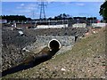
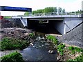
Badenheath Park, Mollins Burn
The burn goes through this culvert which presumably will carry an access road to the big suds ponds.
Image: © Robert Murray
Taken: 25 Apr 2011
0.08 miles
10
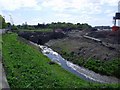
Badenheath Park, Mollins Burn
The diverted Mollins which now empties into Luggie Water south of the new alignment of the M80 whereas beforehand it did so north of the A80.
Image: © Robert Murray
Taken: 25 Apr 2011
0.08 miles