IMAGES TAKEN NEAR TO
Cumbernauld, GLASGOW, G67 4HH
Introduction
This page details the photographs taken nearby to G67 4HH by members of the Geograph project.
The Geograph project started in 2005 with the aim of publishing, organising and preserving representative images for every square kilometre of Great Britain, Ireland and the Isle of Man.

There are currently over 7.5m images from over14,400 individuals and you can help contribute to the project by visiting https://www.geograph.org.uk
Image Map
Images are licensed for reuse under creativecommons.org/licenses/by-sa/2.0
Notes
- Clicking on the map will re-center to the selected point.
- The higher the marker number, the further away the image location is from the centre of the postcode.
Image Listing (8 Images Found)
Images are licensed for reuse under creativecommons.org/licenses/by-sa/2.0
Image
Details
Distance
1
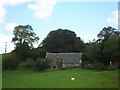
North Medrox Farm
A building of the original farm.
Image: © Robert Murray
Taken: 28 Jun 2011
0.01 miles
2
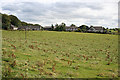
North Medrox
There seem to be several modern houses at North Medrox, all of them standing north of the farm buildings.
Image: © Anne Burgess
Taken: 25 Aug 2015
0.02 miles
3
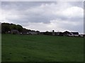
North Medrox Farm
Which looks almost as big as a village. The oldest part of this farm lies to the left in the photo.
Image: © Robert Murray
Taken: 13 May 2010
0.03 miles
4
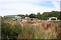
North Medrox
Large barns and waste ground on the south side of North Medrox Farm.
Image: © Anne Burgess
Taken: 25 Aug 2015
0.08 miles
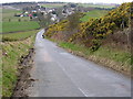
7
Road Junction on Airdrie Road, Mollinsburn
The main road continues to the right as Mollinsburn Road while the minor road straight ahead (Myvot Road) leads to Cumbernauld and other settlements.
Image: © G Laird
Taken: 2 Jan 2014
0.14 miles
8
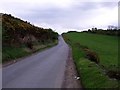
Mollinsburn Road
Near North Medrox with the Kilsyth hills on the horizon.
Image: © Robert Murray
Taken: 28 Jun 2011
0.19 miles