IMAGES TAKEN NEAR TO
Gain and Shankburn Road, GLASGOW, G67 4GZ
Introduction
This page details the photographs taken nearby to Gain and Shankburn Road, G67 4GZ by members of the Geograph project.
The Geograph project started in 2005 with the aim of publishing, organising and preserving representative images for every square kilometre of Great Britain, Ireland and the Isle of Man.

There are currently over 7.5m images from over14,400 individuals and you can help contribute to the project by visiting https://www.geograph.org.uk
Image Map
Images are licensed for reuse under creativecommons.org/licenses/by-sa/2.0
Notes
- Clicking on the map will re-center to the selected point.
- The higher the marker number, the further away the image location is from the centre of the postcode.
Image Listing (4 Images Found)
Images are licensed for reuse under creativecommons.org/licenses/by-sa/2.0
Image
Details
Distance
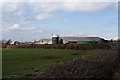
1
Back route into Edengrove
Just south of Wardhead Wood.
Image: © Stephen Sweeney
Taken: 17 Jul 2012
0.04 miles
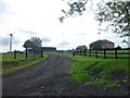
2
House on the Gain and Shankburn Road
Just to the west of Condorrat Road.
Image: © Stephen Sweeney
Taken: 17 Jul 2012
0.18 miles
3
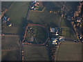
Stables near Cleddans from the air
Stables and gallops on Yetts Hole Road near Cleddans House.
Image: © Thomas Nugent
Taken: 8 Dec 2017
0.20 miles