IMAGES TAKEN NEAR TO
Craigcrest Place, GLASGOW, G67 4GY
Introduction
This page details the photographs taken nearby to Craigcrest Place, G67 4GY by members of the Geograph project.
The Geograph project started in 2005 with the aim of publishing, organising and preserving representative images for every square kilometre of Great Britain, Ireland and the Isle of Man.

There are currently over 7.5m images from over14,400 individuals and you can help contribute to the project by visiting https://www.geograph.org.uk
Image Map
Images are licensed for reuse under creativecommons.org/licenses/by-sa/2.0
Notes
- Clicking on the map will re-center to the selected point.
- The higher the marker number, the further away the image location is from the centre of the postcode.
Image Listing (19 Images Found)
Images are licensed for reuse under creativecommons.org/licenses/by-sa/2.0
Image
Details
Distance
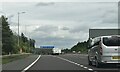
1
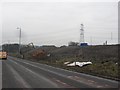
M80 construction
Working on the conversion of the A80 to M80, south of Cumbernauld.
Image: © Richard Webb
Taken: 4 Mar 2011
0.05 miles
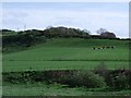
2
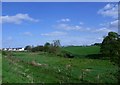
Badenheath Park
Along the Luggie towards new housing at Craigend.
Image: © Robert Murray
Taken: 25 Apr 2011
0.09 miles
3
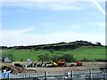
M80 motorway construction
Between Condorrat and Mollinsburn.
Image: © Robert Murray
Taken: 10 Apr 2010
0.09 miles
5
Badenheath Park
The banks of the Luggie Water in the foreground.
Image: © Robert Murray
Taken: 25 Apr 2011
0.11 miles
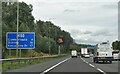
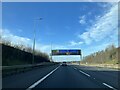
7
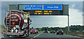
Gantry sign on the M80 motorway
Approaching Junction 4 from the north.
Image: © Thomas Nugent
Taken: 30 Jul 2017
0.15 miles
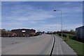
10
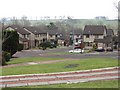
Medrox Gardens
New houses, Dalshannon.
Image: © Richard Webb
Taken: 4 Mar 2011
0.18 miles