IMAGES TAKEN NEAR TO
Cumbernauld, GLASGOW, G67 4FE
Introduction
This page details the photographs taken nearby to G67 4FE by members of the Geograph project.
The Geograph project started in 2005 with the aim of publishing, organising and preserving representative images for every square kilometre of Great Britain, Ireland and the Isle of Man.

There are currently over 7.5m images from over14,400 individuals and you can help contribute to the project by visiting https://www.geograph.org.uk
Image Map
Images are licensed for reuse under creativecommons.org/licenses/by-sa/2.0
Notes
- Clicking on the map will re-center to the selected point.
- The higher the marker number, the further away the image location is from the centre of the postcode.
Image Listing (10 Images Found)
Images are licensed for reuse under creativecommons.org/licenses/by-sa/2.0
Image
Details
Distance
1
Demolition at South Myvot
Work has been ongoing at this old farm for a few years and it is likely to culminate in a new dwelling of sorts.
Image: © Robert Murray
Taken: 12 Apr 2010
0.00 miles
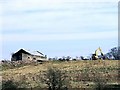
2
South Myvot
The buildings at South Myvot are now just part of several piles of rubble. Cumbernauld is in the background.
Image: © Anne Burgess
Taken: 25 Aug 2015
0.01 miles
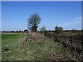
3
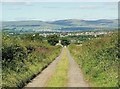
Farm Track to South Myvot
Image: © Texas Radio and The Big Beat
Taken: 30 Aug 2010
0.10 miles
4
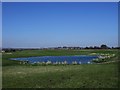
Pond at North Myvot
The existence of this pond which is permanent except in periods of drought is probably due to minor subsidence incurred by the decaying matter below.
Image: © Robert Murray
Taken: 12 Apr 2010
0.12 miles
5
Maryburgh Sidings
This was the spot that the railway sidings used to dump the rubbish from Glasgow took a spur from the main line. The sidings were owned by Glasgow Corporation and named after a steading (which disappeared during the life of the dump) situated on the land.
Image: © Robert Murray
Taken: 12 Apr 2010
0.14 miles
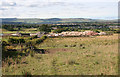
6
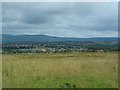
View across Condorrat and Balloch
From Summerhill and Garngibbock Road.
Image: © Stephen Sweeney
Taken: 17 Jul 2012
0.14 miles
7
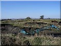
Soil extraction, North Myvot
This soil extraction operation is a relic of Victorian Glasgow.
The fields around here were a Victorian rubbish tip - what we now politely call a landfill site. Rubbish from Glasgow was transported here by train in the nineteenth and early twentieth centuries and tipped off the wagons. One hundred years later this rubbish (free of plastics and other modern contaminants) is the deepest black soil you'll find anywhere.
Image: © Robert Murray
Taken: 12 Apr 2010
0.17 miles
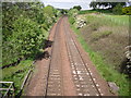
8
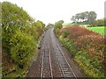
Caledonian Railway
Looking northwards on the line which now links Glasgow with Cumbernauld.
Image: © Richard Webb
Taken: 18 Oct 2010
0.19 miles
9
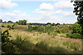
Glacial Meltwater Channel
The burn is so small relative to the wide channel that it cannot possibly be the agent that created the channel. It was almost certainly created by melting ice at the end of the last Ice Age.
Image: © Anne Burgess
Taken: 10 Jul 2014
0.22 miles