IMAGES TAKEN NEAR TO
Locksley Crescent, GLASGOW, G67 4EL
Introduction
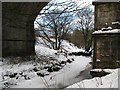
This page details the photographs taken nearby to Locksley Crescent, G67 4EL by members of the Geograph project.
The Geograph project started in 2005 with the aim of publishing, organising and preserving representative images for every square kilometre of Great Britain, Ireland and the Isle of Man.

There are currently over 7.5m images from over14,400 individuals and you can help contribute to the project by visiting https://www.geograph.org.uk
Image Map
Images are licensed for reuse under creativecommons.org/licenses/by-sa/2.0
Notes
- Clicking on the map will re-center to the selected point.
- The higher the marker number, the further away the image location is from the centre of the postcode.
Image Listing (44 Images Found)
Images are licensed for reuse under creativecommons.org/licenses/by-sa/2.0
Image
Details
Distance
1
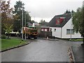
Road repair, Locksley Road
Residential Cumbernauld, in the rain.
Image: © Richard Webb
Taken: 18 Oct 2010
0.07 miles
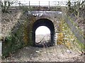
2
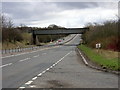
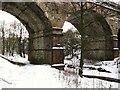
Railway Bridge Over A73
Railway bridge carrying the Glasgow to Cumbernauld line over the A73
Image: © Iain Thompson
Taken: 16 Apr 2006
0.07 miles
3
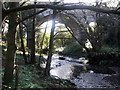
Luggie Water at Garngibboch Railway Bridge
Image: © Texas Radio and The Big Beat
Taken: 10 Jan 2010
0.10 miles
4
Railway bridge over the Luggie Water
In Cumbernauld.
Image: © Stephen Sweeney
Taken: 17 Jul 2012
0.11 miles
5
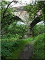
Railway bridge at Garngibboch
This bridge built by the Caledonian Railway Company carries the modern Glasgow to Falkirk line over Luggie Water.
Image: © Robert Murray
Taken: 16 Oct 2009
0.11 miles
6
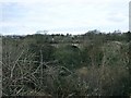
Viaduct over Luggie Water
A view from the fields to the south.
Image: © Robert Murray
Taken: 6 Mar 2010
0.11 miles
7
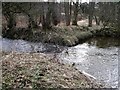
Meeting of the waters
From the left the Shank Burn (which it could be said is almost a river) after emerging from under the railway embankment joins the Luggie Water north east of Garngibboch.
Image: © Robert Murray
Taken: 6 Mar 2010
0.12 miles
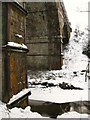
8
Railway Bridge at Garngibboch
Image: © Texas Radio and The Big Beat
Taken: 10 Jan 2010
0.12 miles
9
Luggie Water at Garngibboch Railway Bridge
Image: © Texas Radio and The Big Beat
Taken: 10 Jan 2010
0.12 miles
10
Pettycastle Railway Bridge
Built to allow the good folk of Pettycastle and Wester Blairlinn access across the ford on the Luggie Water. This little (if at all) used access route is remarkably free of obstruction. It is so forgotten that it has no Network Rail bridge number.
Image: © Robert Murray
Taken: 6 Mar 2010
0.14 miles