IMAGES TAKEN NEAR TO
Waverley Crescent, GLASGOW, G67 4BG
Introduction
This page details the photographs taken nearby to Waverley Crescent, G67 4BG by members of the Geograph project.
The Geograph project started in 2005 with the aim of publishing, organising and preserving representative images for every square kilometre of Great Britain, Ireland and the Isle of Man.

There are currently over 7.5m images from over14,400 individuals and you can help contribute to the project by visiting https://www.geograph.org.uk
Image Map
Images are licensed for reuse under creativecommons.org/licenses/by-sa/2.0
Notes
- Clicking on the map will re-center to the selected point.
- The higher the marker number, the further away the image location is from the centre of the postcode.
Image Listing (9 Images Found)
Images are licensed for reuse under creativecommons.org/licenses/by-sa/2.0
Image
Details
Distance
1
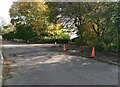
Pavement under repair
Where footpath crosses Athelstane Drive
Image: © Jim Smillie
Taken: 14 Oct 2023
0.11 miles
2
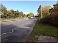
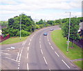
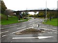
A8011: Glasgow Road
Linking Cumbernauld town centre with the M80 Glasgow-Stirling
Image: © Jim Smillie
Taken: 14 Oct 2023
0.11 miles
3
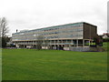
Greenfaulds High School
On Athelstane Drive, Cumbernauld, Greenfaulds High School is a non-denominational six year comprehensive secondary school, which was opened in 1971.
Image: © G Laird
Taken: 5 Jan 2014
0.17 miles
4
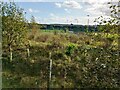
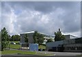
View though wooded strip of land to Greenfaulds High School
New school building opened in 2016
Image: © Jim Smillie
Taken: 14 Oct 2023
0.19 miles
6
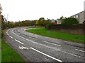
Greenfaulds Road
A loop road serving a residential area of Cumbernauld.
Image: © Richard Webb
Taken: 18 Oct 2010
0.21 miles
8
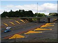
Cumbernauld's Light Sculpture
Part of the Cumbernauld Positive Image Campaign.
"The special effects are achieved by fins positioned on the embankments
of at A8011 - the approach road to the town centre. The intention is to
emulate the feeling of driving alongside a giant wave." Cumbernauld News.
See also www.geograph.org.uk/photo/2039507
Image: © Texas Radio and The Big Beat
Taken: 29 Aug 2010
0.23 miles
9
Greenfaulds Road
A loop road serving a residential area of Cumbernauld.
Image: © Richard Webb
Taken: 18 Oct 2010
0.25 miles