IMAGES TAKEN NEAR TO
Marmion Road, GLASGOW, G67 4AN
Introduction
This page details the photographs taken nearby to Marmion Road, G67 4AN by members of the Geograph project.
The Geograph project started in 2005 with the aim of publishing, organising and preserving representative images for every square kilometre of Great Britain, Ireland and the Isle of Man.

There are currently over 7.5m images from over14,400 individuals and you can help contribute to the project by visiting https://www.geograph.org.uk
Image Map
Images are licensed for reuse under creativecommons.org/licenses/by-sa/2.0
Notes
- Clicking on the map will re-center to the selected point.
- The higher the marker number, the further away the image location is from the centre of the postcode.
Image Listing (11 Images Found)
Images are licensed for reuse under creativecommons.org/licenses/by-sa/2.0
Image
Details
Distance
1
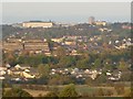
Cumbernauld
The south western area of the town featuring parts of Condorrat, Greenfaulds and the town centre sky line. The photo was taken from the ridge east of Mollinsburn.
Image: © Robert Murray
Taken: 10 Oct 2007
0.08 miles
2
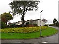
Ashiestiel Road
A residential area of Greenfaulds, Cumbernauld.
Image: © Richard Webb
Taken: 18 Oct 2010
0.17 miles
3
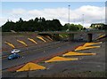
Cumbernauld's Light Sculpture
Part of the Cumbernauld Positive Image Campaign.
"The special effects are achieved by fins positioned on the embankments
of at A8011 - the approach road to the town centre. The intention is to
emulate the feeling of driving alongside a giant wave." Cumbernauld News.
See also www.geograph.org.uk/photo/2039507
Image: © Texas Radio and The Big Beat
Taken: 29 Aug 2010
0.18 miles
4
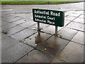
Cumbernauld street sign
A great help in trying not to get lost. New towns have found an unexpected new use as a sporting venue, they are excellent orienteering areas.
Image: © Richard Webb
Taken: 18 Oct 2010
0.19 miles
5
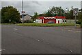
The Tyre Station
Beside access to small Greenfaulds Station car park
Image: © Jim Smillie
Taken: 30 Sep 2023
0.20 miles
6
Greenfaulds Railway Station, Cumbernauld
Greenfaulds railway station serves the Greenfaulds area of Cumbernauld, North Lanarkshire, Scotland.
Image: © Stevie Spiers
Taken: 16 Sep 2007
0.23 miles
7
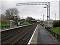
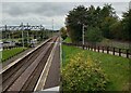
Greenfaulds Railway Station
The station between Gartcosh and Cumbernauld railway stations on the Cumbernauld line. It is also the station between Coatbridge Central and Cumbernauld railway stations on the Motherwell to Cumbernauld line.
Preparations are being made to electrify the line.
Image: © G Laird
Taken: 5 Jan 2014
0.24 miles
8
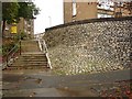
Ivanhoe to Abbotsford
Wattie Scott fans in this part of the town planning project. The steps link Abbotsford Road with Ivanhoe Road in Cumbernauld.
Image: © Richard Webb
Taken: 18 Oct 2010
0.24 miles
9
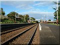
Greenfaulds Station
A small corner of a large Park & Ride car park on left
Image: © Jim Smillie
Taken: 30 Sep 2023
0.25 miles
10
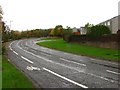
Greenfaulds Road
A loop road serving a residential area of Cumbernauld.
Image: © Richard Webb
Taken: 18 Oct 2010
0.25 miles